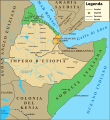
File:Ethiopia Map 1930 it.svg
Appearance

Size of this PNG preview of this SVG file: 550 × 599 pixels. Other resolutions: 220 × 240 pixels | 441 × 480 pixels | 705 × 768 pixels | 940 × 1,024 pixels | 1,880 × 2,048 pixels | 559 × 609 pixels.
Original file (SVG file, nominally 559 × 609 pixels, file size: 538 KB)
File history
Click on a date/time to view the file as it appeared at that time.
| Date/Time | Thumbnail | Dimensions | User | Comment | |
|---|---|---|---|---|---|
| current | 22:29, 8 February 2018 |  | 559 × 609 (538 KB) | Ruthven | Yemen |
| 14:30, 8 February 2018 |  | 559 × 609 (496 KB) | Ruthven | Somalia francese | |
| 16:14, 6 February 2018 |  | 559 × 609 (486 KB) | Ruthven | casus belli a Ual Ual | |
| 15:14, 3 February 2018 |  | 559 × 609 (470 KB) | Ruthven | strade del 1930 e ferrovie | |
| 10:29, 4 January 2018 |  | 559 × 609 (503 KB) | MacMoreno | Inseriti prcorsi fiumi principali | |
| 23:31, 3 January 2018 |  | 559 × 609 (409 KB) | MacMoreno | Correzioni minori sulla grafica | |
| 23:13, 3 January 2018 |  | 559 × 609 (406 KB) | Ruthven | Transferred from it.wikipedia |
File usage
The following page uses this file:
Global file usage
The following other wikis use this file:
- Usage on it.wikipedia.org
- Usage on simple.wikipedia.org


