Jump to content

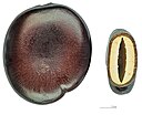
File:Entada phaseoloides MHNT graines.jpg

Page contents not supported in other languages.
This is a file from the Wikimedia Commons
From Wikipedia, the free encyclopedia

Original file (3,702 × 2,856 pixels, file size: 4.74 MB, MIME type: image/jpeg)

Entada phaseoloides (L.) Merr. 1914

Photographer
Description
Deutsch: Entada phaseoloides , Samen. Die Samen können durch den luftgefüllten Hohlraum zwischen den beiden Keimblättern schwimmen (Nautochorie).
English: Entada phaseoloides, seeds. The seeds can float in water, as there is an air cavity between the two cotyledons (Hydrochory).
Français : Entada phaseoloides, graines. Les graines peuvent flotter grâce à une cavité aérienne entre les deux cotylédons (nautochorie).
Place of discovery
InfoField
Deutsch: Verteilung aus dem Pazifik durch den tropischen Australien, westwärts nach Nordvietnam und Südchina, in Malaysia, die Philippinen, Borneo, Sumatra, Java, Sulawesi und den Kleinen Sunda aufgezeichnet . Provenienz: Masoala Halbinsel, Madagaskar.
English: Distribution : from the Pacific through tropical Australia, westward to northern Vietnam and southern China; recorded in Malaysia, the Philippines, Borneo, Sumatra, Java, Sulawesi and the Lesser Sunda.. Provenance : Masoala Peninsula, Madagascar.
Français : Distribution: du Pacifique à l'Australie tropicale, vers l'ouest, au nord du Vietnam et de la Chine méridionale; mais aussi en Malaisie, aux Philippines, Bornéo, Sumatra, Java, Sulawesi et la Sonde. Provenance: Presqu'île de Masoala, Madagascar.
Date 26 December 2012
institution QS:P195,Q422
Source Own work
Permission
(Reusing this file)
I, the copyright holder of this work, hereby publish it under the following license:
w:en:Creative Commons
attribution share alike
This file is licensed under the Creative Commons Attribution-Share Alike 4.0 International license.
You are free:
  • to share – to copy, distribute and transmit the work
  • to remix – to adapt the work
Under the following conditions:
  • attribution – You must give appropriate credit, provide a link to the license, and indicate if changes were made. You may do so in any reasonable manner, but not in any way that suggests the licensor endorses you or your use.
  • share alike – If you remix, transform, or build upon the material, you must distribute your contributions under the same or compatible license as the original.
Other versions
Camera location43° 35′ 38.03″ N, 1° 26′ 57.23″ E Kartographer map based on OpenStreetMap.View this and other nearby images on: OpenStreetMapinfo

Focus stacking of 5 pictures.

Assessment

Quality image
Quality image
Valued image
Valued image
This file is marked as a valued image, but it is missing its scope! Please refer to Template:Assessments/doc!

Wikimedia Commons

This is a quality image' and is considered to meet the quality image guidelines.
This image has been assessed under the valued image criteria and is considered the most
valued image on Commons within the scope '. See its nomination here.

If you think this file should be featured on Wikimedia Commons as well, feel free to nominate it.
If you have an image of similar quality that can be published under a suitable copyright license, be sure to upload it, tag it, and nominate it.

Captions

Add a one-line explanation of what this file represents

Items portrayed in this file

depicts

26 December 2012

43°35'38.02980593962"N, 1°26'57.22698211670"E

File history

Click on a date/time to view the file as it appeared at that time.

Date/TimeThumbnailDimensionsUserComment
current08:33, 26 December 2012Thumbnail for version as of 08:33, 26 December 20123,702 × 2,856 (4.74 MB)Archaeodontosaurus{{Information |Description ={{en|1=c}} |Source ={{own}} |Author =Archaeodontosaurus |Date = |Permission = |other_versions = }}

Global file usage

The following other wikis use this file:

Metadata