Jump to content

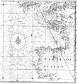
File:EdwardWright-MapforSailingtoAzores-1599.jpg

Page contents not supported in other languages.
This is a file from the Wikimedia Commons
From Wikipedia, the free encyclopedia

EdwardWright-MapforSailingtoAzores-1599.jpg (477 × 518 pixels, file size: 96 KB, MIME type: image/jpeg)

Summary

Description
English: English mathematician and cartographer Edward Wright's map "for sailing to the Isles of Azores", which was constructed according to the Mercator projection which Wright explained in his work Certaine Errors of Navigation (1599). The star-like grid of lines are loxodromes or rhumb lines.
Date
Source Edward Wright (1599) Certaine Errors in Navigation, arising either of the Ordinarie Erroneous Making or Vsing of the Sea Chart, Compasse, Crosse Staffe, and Tables of Declination of the Sunne, and Fixed Starres Detected and Corrected. (The Voyage of the Right Ho. George Earle of Cumberl. to the Azores, &c.), London: Printed ... by Valentine Simmes Reproduced as fig. 2.10 of Paul J. Lewi (2006-02-11) "Mercator, Wright and Mapmaking" in Speaking of Graphics: An Essay on Graphicacy in Science, Technology and Business, Turnhout, Belgium: DataScope, pp. 30
Author Edward Wright

Licensing

Public domain

This work is in the public domain in its country of origin and other countries and areas where the copyright term is the author's life plus 100 years or fewer.


You must also include a United States public domain tag to indicate why this work is in the public domain in the United States.
This file has been identified as being free of known restrictions under copyright law, including all related and neighboring rights.

Captions

Add a one-line explanation of what this file represents

Items portrayed in this file

depicts

image/jpeg

File history

Click on a date/time to view the file as it appeared at that time.

Date/TimeThumbnailDimensionsUserComment
current16:45, 5 May 2008Thumbnail for version as of 16:45, 5 May 2008477 × 518 (96 KB)Jacklee==Summary== {{Information |Description = {{en|English mathematician and cartographer Edward Wright's map "for sailing to the Isles of Azores", which wa

Global file usage

The following other wikis use this file:

Metadata