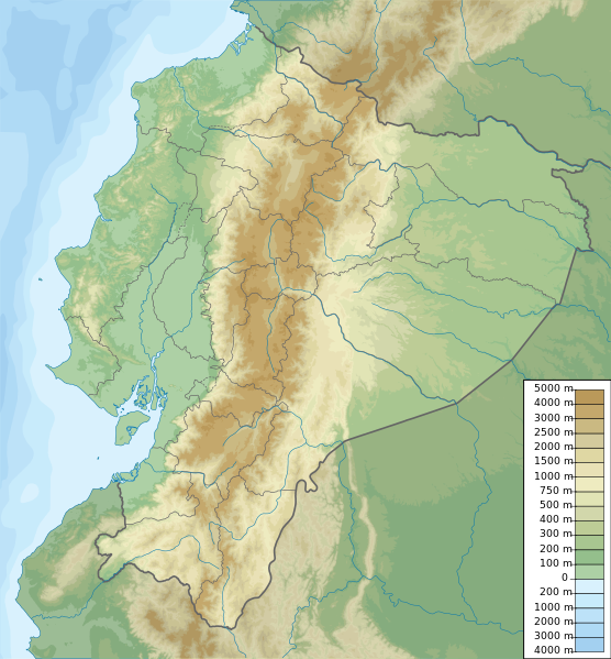
File:Ecuador relief location map.svg
Appearance

Size of this PNG preview of this SVG file: 556 × 599 pixels. Other resolutions: 223 × 240 pixels | 445 × 480 pixels | 713 × 768 pixels | 950 × 1,024 pixels | 1,901 × 2,048 pixels | 851 × 917 pixels.
Original file (SVG file, nominally 851 × 917 pixels, file size: 3.76 MB)
File history
Click on a date/time to view the file as it appeared at that time.
| Date/Time | Thumbnail | Dimensions | User | Comment | |
|---|---|---|---|---|---|
| current | 19:49, 15 October 2012 |  | 851 × 917 (3.76 MB) | Milenioscuro | corrections of coastal line and boundaries (according to Ecuador location map.svg) |
| 15:16, 26 August 2012 |  | 1,536 × 1,654 (2.49 MB) | Joffrenomuere | son 24 Provincias no 22 | |
| 08:04, 15 June 2012 |  | 851 × 917 (2.13 MB) | TUBS | rv: please follow map conventions, cf your disk | |
| 18:53, 13 June 2012 |  | 851 × 917 (2.35 MB) | Joffrenomuere | 24 provincias | |
| 19:00, 14 March 2011 |  | 851 × 917 (2.13 MB) | Urutseg |
File usage
More than 100 pages use this file. The following list shows the first 100 pages that use this file only. A full list is available.
- 1797 Riobamba earthquake
- 1868 Ecuador earthquakes
- 1906 Ecuador–Colombia earthquake
- 1949 Ambato earthquake
- 1958 Ecuador–Colombia earthquake
- 1987 Ecuador earthquakes
- 1998 Bahía de Caráquez earthquake
- 2014 Ecuador earthquake
- 2016 Ecuador earthquake
- Antisana
- Arajuno Canton
- Arenillas Ecological Reserve
- Arenillas River
- Atacazo
- Atelopus onorei
- Balao River
- Carihuairazo
- Cayambe (volcano)
- Cayapas River
- Cazaderos Formation
- Cañar River
- Cerro Negro de Mayasquer
- Cerro de Arcos
- Chacana
- Chiles (volcano)
- Chimborazo
- Chone River
- Coaque River
- Cochasquí
- Cojimies River
- Corazón (volcano)
- Cordillera del Cóndor
- Cotacachi Cayapas Ecological Reserve
- Cotacachi Volcano
- Cotopaxi
- Cotopaxi National Park
- Cueva de los Tayos
- Cuyabeno Wildlife Reserve
- El Altar
- El Cajas National Park
- Ensenada de Mompiche
- Esmeraldas River
- Geography of Ecuador
- Guayaquil
- Guayas River
- Hyloscirtus tapichalaca
- Iliniza Sur
- Illiniza
- Imbabura Volcano
- Inca-Caranqui
- Ingapirca
- Jama River
- Jipijapa River
- Jubones River
- Lake Pilchicocha
- List of gomphothere fossils in South America
- List of volcanoes in Ecuador
- Llanganates National Park
- Machalilla National Park
- Mache River
- Mapasingue
- Maquipucuna
- Mazar Dam
- Mikakucha
- Muisne River
- Ninahuilca
- Pambamarca
- Pambamarca Fortress Complex
- Pasochoa
- Paute Dam
- Pichincha (volcano)
- Podocarpus National Park
- Portoviejo River
- Pristimantis ecuadorensis
- Quilotoa
- Quito
- Quito Astronomical Observatory
- Quito Open (golf)
- Ratas, ratones, rateros
- Refugio Paz de Las Aves
- Reventador
- Rumicucho
- Rumiñahui (volcano)
- Sangay
- Sangay National Park
- Sincholagua Volcano
- Sumaco
- Sumaco Napo-Galeras National Park
- Tungurahua
- Valencia, Ecuador
- Yacurí National Park
- Yawarkucha
- User:Dr. Blofeld/DYK A-Z country challenge
- User:Ty654/List of earthquakes exceeding magnitude 8+
- User:Ty654/List of earthquakes from 1900-1949 exceeding magnitude 7+
- User:Ty654/List of earthquakes from 1930-1939 exceeding magnitude 6+
- User:Ty654/List of earthquakes from 1950-1999 exceeding magnitude 7+
- User:Ty654/List of earthquakes from 2000-present exceeding magnitude 7+
- Wikipedia:WikiProject Rosblofnari/DYK A-Z country challenge
- Template:Volcanoes in Ecuador
View more links to this file.
Global file usage
The following other wikis use this file:
- Usage on ar.wikipedia.org
- Usage on ast.wikipedia.org
- Usage on azb.wikipedia.org
- Usage on az.wikipedia.org
- Usage on ban.wikipedia.org
- Usage on be.wikipedia.org
- Usage on bg.wikipedia.org
- Usage on bh.wikipedia.org
- Usage on bn.wikipedia.org
- Usage on bs.wikipedia.org
View more global usage of this file.
