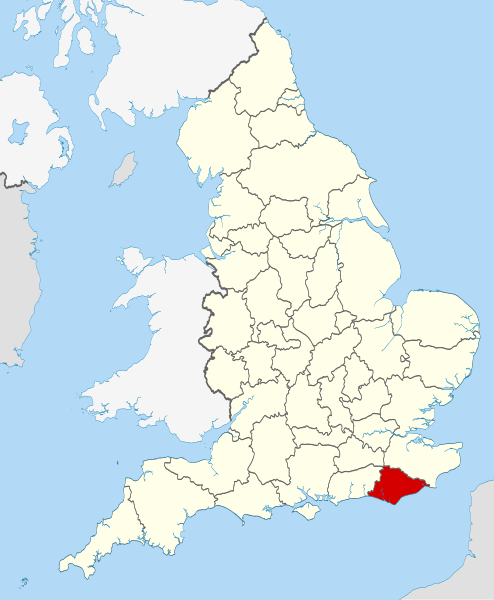
File:East Sussex UK locator map 2010.svg
Appearance

Size of this PNG preview of this SVG file: 494 × 600 pixels. Other resolutions: 198 × 240 pixels | 395 × 480 pixels | 633 × 768 pixels | 843 × 1,024 pixels | 1,687 × 2,048 pixels | 1,108 × 1,345 pixels.
Original file (SVG file, nominally 1,108 × 1,345 pixels, file size: 302 KB)
File history
Click on a date/time to view the file as it appeared at that time.
| Date/Time | Thumbnail | Dimensions | User | Comment | |
|---|---|---|---|---|---|
| current | 22:35, 23 November 2010 |  | 1,108 × 1,345 (302 KB) | Nilfanion | == Summary == {{Information |Description=Location of the ceremonial county of East Sussex within England. |Source=Ordnance Survey [https://www.ordnancesurvey.co.uk/opendatadownload/products.html OpenData]: *County b |
File usage
The following 78 pages use this file:
- Baldslow
- Beachy Head West
- Belmont, East Sussex
- Best Beech Hill
- Blackham
- Bodle Street Green
- Boreham Street
- Broad Oak, Rother
- Broad Oak, Wealden
- Chailey Common
- Cliffe Hill
- Cooper's Green
- Cowbeech
- Dallington, East Sussex
- Darwell Reservoir
- Denton, East Sussex
- Doleham
- Duddleswell
- East Blatchington
- East Guldeford
- East Sussex
- Etchingwood
- Fairwarp
- Five Ash Down
- Fletching, East Sussex
- Gensing, East Sussex
- Golden Cross, East Sussex
- Grade II* listed buildings in East Sussex
- Grade I listed buildings in East Sussex
- Gun Hill, East Sussex
- High Hurstwood
- Hove Park
- Icklesham
- Iden, East Sussex
- Jarvis Brook
- Little Horsted
- Lullington, East Sussex
- Magham Down
- Maynard's Green
- Netherfield, East Sussex
- Newhaven Seaplane Base
- Normans Bay
- Piltdown
- Playden
- Plumpton Racecourse
- Poundgate
- Preston, Brighton
- Quadrophenia Alley
- Queen's Park (Brighton ward)
- Ridgewood, East Sussex
- River Uck
- Rock-a-Nore
- Roser's Cross
- Royal Military Canal Path
- Royal Sovereign shoal
- Rushlake Green
- Rye Foreign
- Rye Harbour SSSI
- Salehurst and Robertsbridge
- Seahaven, East Sussex
- Sidley, East Sussex
- Southern Sandstone
- St Alban's Church, Frant
- St Ann Without
- Sussex Downs AONB
- Sussex Ouse Valley Way
- Udimore
- Upper Hartfield
- Vines Cross
- Wartling
- West Hill, Brighton
- Winchelsea Beach
- Windmill Hill, East Sussex
- Windycroft
- Withdean
- Woodingdean Water Well
- User:Roypenfold/America Ground
- Template:EastSussex-geo-stub
Global file usage
The following other wikis use this file:
- Usage on af.wikipedia.org
- Usage on ar.wikipedia.org
- Usage on ast.wikipedia.org
- Usage on be-tarask.wikipedia.org
- Usage on bg.wikipedia.org
- Usage on ca.wikipedia.org
- Usage on ceb.wikipedia.org
- Usage on cs.wikipedia.org
- Usage on dag.wikipedia.org
- Usage on eo.wikipedia.org
- Usage on es.wikipedia.org
- Usage on eu.wikipedia.org
- Usage on fa.wikipedia.org
- Usage on fi.wikipedia.org
- Usage on fr.wiktionary.org
- Usage on ga.wikipedia.org
- Usage on gl.wikipedia.org
- Usage on hak.wikipedia.org
- Usage on hr.wikipedia.org
- Usage on hu.wikipedia.org
- Usage on hy.wikipedia.org
- Usage on ia.wikipedia.org
- Usage on ja.wikipedia.org
- Usage on ko.wikipedia.org
- Usage on la.wikipedia.org
- Usage on lld.wikipedia.org
- Usage on lt.wikipedia.org
- Usage on lv.wikipedia.org
- Usage on mr.wikipedia.org
- Usage on nl.wikipedia.org
- Usage on oc.wikipedia.org
- Usage on os.wikipedia.org
- Usage on pl.wikipedia.org
- Usage on pl.wikivoyage.org
- Usage on pl.wiktionary.org
- Usage on pnb.wikipedia.org
- Usage on pt.wikipedia.org
- Usage on sh.wikipedia.org
- Usage on sr.wikipedia.org
- Usage on sv.wikipedia.org
View more global usage of this file.


