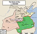
File:EN-CHU260BCE.jpg
Appearance

Size of this preview: 651 × 599 pixels. Other resolutions: 261 × 240 pixels | 522 × 480 pixels | 834 × 768 pixels | 1,113 × 1,024 pixels | 2,225 × 2,048 pixels | 4,724 × 4,348 pixels.
Original file (4,724 × 4,348 pixels, file size: 1.81 MB, MIME type: image/jpeg)
File history
Click on a date/time to view the file as it appeared at that time.
| Date/Time | Thumbnail | Dimensions | User | Comment | |
|---|---|---|---|---|---|
| current | 16:40, 17 October 2013 |  | 4,724 × 4,348 (1.81 MB) | Iflwlou | change |
| 02:06, 29 October 2010 |  | 4,724 × 4,348 (3.79 MB) | Benjamin Trovato | {{Information |Description={{en|1=China Map, Chu State, 260BCE}} |Source={{own}} |Author=Philg88 |Date=2010-10-28 |Permission= |other_versions=ZH-楚国地图260BCE }} |
File usage
The following page uses this file:
Global file usage
The following other wikis use this file:
- Usage on ar.wikipedia.org
- Usage on be.wikipedia.org
- Usage on ca.wikipedia.org
- Usage on ce.wikipedia.org
- Usage on de.wikipedia.org
- Usage on es.wikipedia.org
- Usage on et.wikipedia.org
- Usage on fi.wikipedia.org
- Usage on hi.wikipedia.org
- Usage on hr.wikipedia.org
- Usage on id.wikipedia.org
- Usage on lt.wikipedia.org
- Usage on mn.wikipedia.org
- Usage on nn.wikipedia.org
- Usage on pl.wikipedia.org
- Usage on pt.wikipedia.org
- Usage on ro.wikipedia.org
- Usage on ru.wikipedia.org
- Usage on uk.wikipedia.org
- Usage on ur.wikipedia.org
- Usage on www.wikidata.org


