Jump to content

File:ECDM 20240123 China earthquake and landslide.pdf

Page contents not supported in other languages.
This is a file from the Wikimedia Commons
From Wikipedia, the free encyclopedia

Original file (1,625 × 1,125 pixels, file size: 726 KB, MIME type: application/pdf)

Summary

Description
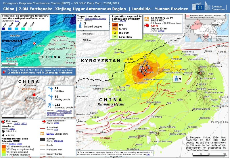
English: China | 7.0M Earthquake - Xianjiang Uygur Autonomous Region | Landslide - Yunnan Province

ECHO Daily Map of 23 January 2024
Date
Source https://erccportal.jrc.ec.europa.eu/ECHO-Products/Maps#/maps/4765
Author Emergency Response Coordination Centre with Sources: GDACS, USGS, GEM, JRC GHSL, Government of Xinjiang, Department of Emergency management of Yunnan Province, NOAA GFS

Licensing

Public domain
Public documents (any content whatever its medium) produced by the Commission or by entities on its behalf published by the Commission or the Publications Office or which have not been published for economic or other practical reasons, such as studies, reports and other data shall be made available for reuse unless otherwise specified[1] without restrictions according to 2011/833/EU: Commission Decision of 12 December 2011 on the reuse of Commission documents

Note: Content on ec.europa.eu or its data portal is published with the specified restrictions of the CC BY 4.0 license.

  1. These restrictions may include attribution, "the obligation not to distort the original meaning or message of the documents, or the non-liability of the Commission for any consequence stemming from the reuse"

English  日本語  +/−

Captions

Add a one-line explanation of what this file represents

Items portrayed in this file

depicts

743,434 byte

1,125 pixel

1,625 pixel

application/pdf

294e559588532bd6846918b945e3aecd122f8e01

File history

Click on a date/time to view the file as it appeared at that time.

Date/TimeThumbnailDimensionsUserComment
current21:40, 3 April 2024Thumbnail for version as of 21:40, 3 April 20241,625 × 1,125 (726 KB)Don-vipnew version with fixed typo Xianjiang => Xinjiang
22:55, 23 January 2024Thumbnail for version as of 22:55, 23 January 20241,625 × 1,125 (726 KB)LupeUploaded a work by Emergency Response Coordination Centre with Sources: GDACS, USGS, GEM, JRC GHSL, Government of Xinjiang, Department of Emergency management of Yunnan Province, NOAA GFS from https://erccportal.jrc.ec.europa.eu/ECHO-Products/Maps#/maps/4765 with UploadWizard

The following page uses this file:

Global file usage

The following other wikis use this file:

Metadata