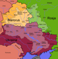
File:Dnieper Basin River Town Polski.png
Appearance

Size of this preview: 583 × 600 pixels. Other resolutions: 233 × 240 pixels | 467 × 480 pixels | 746 × 768 pixels | 1,180 × 1,214 pixels.
Original file (1,180 × 1,214 pixels, file size: 129 KB, MIME type: image/png)
File history
Click on a date/time to view the file as it appeared at that time.
| Date/Time | Thumbnail | Dimensions | User | Comment | |
|---|---|---|---|---|---|
| current | 14:32, 18 September 2017 |  | 1,180 × 1,214 (129 KB) | Nicolay Sidorov | ... |
| 08:37, 7 March 2007 |  | 1,180 × 1,214 (396 KB) | Dcoetzee | Removed watermark, pngcrushed | |
| 15:29, 14 February 2006 |  | 1,180 × 1,214 (601 KB) | Francis McLloyd | Category:Maps of Ukraine Category:Maps of countries |
File usage
The following page uses this file:
Global file usage
The following other wikis use this file:
- Usage on ceb.wikipedia.org
- Usage on cs.wikipedia.org
- Usage on da.wikipedia.org
- Usage on de.wikipedia.org
- Usage on fa.wikipedia.org
- Usage on fr.wikipedia.org
- Usage on id.wikipedia.org
- Usage on nn.wikipedia.org
- Mal:Dnepr
- Dnepr
- Berezina
- Drut
- Pripjat
- Sozj
- Vorskla
- Psel
- Desna
- Vop
- Vjazma ved Dnepr
- Khmost
- Dnepr-reservoaret
- Kamjanske-reservoaret
- Kakhovka-reservoaret
- Kaniv-reservoaret
- Kiev-reservoaret
- Krementsjuk-reservoaret
- Bazavluk
- Inhulets
- Irpin-elva
- Roselva
- Samara ved Dnepr
- Stuhna
- Sulaelva
- Teteriv
- Trubizj
- Tjasmyn
- Zolotonosjka
- Konka
- Usage on pl.wikipedia.org
- Usage on tr.wikipedia.org
- Usage on uk.wikipedia.org


