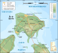
File:Djerba topographic map-fr.svg
Appearance

Size of this PNG preview of this SVG file: 666 × 599 pixels. Other resolutions: 267 × 240 pixels | 533 × 480 pixels | 853 × 768 pixels | 1,138 × 1,024 pixels | 2,276 × 2,048 pixels | 1,100 × 990 pixels.
Original file (SVG file, nominally 1,100 × 990 pixels, file size: 564 KB)
File history
Click on a date/time to view the file as it appeared at that time.
| Date/Time | Thumbnail | Dimensions | User | Comment | |
|---|---|---|---|---|---|
| current | 01:09, 1 September 2008 |  | 1,100 × 990 (564 KB) | Sting | New standard colors |
| 20:07, 5 December 2007 |  | 1,100 × 990 (571 KB) | Sting | Forgotten village name | |
| 10:44, 5 December 2007 |  | 1,100 × 990 (571 KB) | Sting | "Ras Rmel" typo correction | |
| 23:11, 4 December 2007 |  | 1,100 × 990 (571 KB) | Sting | {{Location|33|45|00|N|10|55|00|E|scale:500000}} <br/> {{Information |Description=Topographic map in French of Djerba Island, Tunisia |Source=Own work ;<br/>Topographic map : [http://www2.jpl.nasa.gov/srtm NASA Shuttle Radar Topography Missi |
File usage
The following page uses this file:
Global file usage
The following other wikis use this file:
- Usage on da.wikipedia.org
- Usage on eo.wikipedia.org
- Usage on fa.wikipedia.org
- Usage on fr.wikipedia.org
- Usage on fr.wiktionary.org
- Usage on he.wikipedia.org
- Usage on incubator.wikimedia.org
- Usage on it.wikipedia.org
- Usage on lad.wikipedia.org
- Usage on pl.wikipedia.org
- Usage on pt.wikipedia.org
- Usage on sco.wikipedia.org
- Usage on sc.wikipedia.org
- Usage on uz.wikipedia.org


