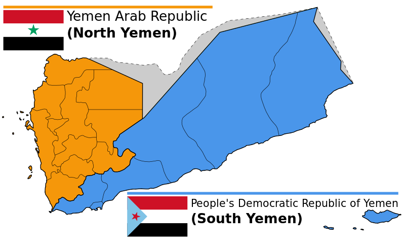
File:Divided Yemen.svg
Appearance

Size of this PNG preview of this SVG file: 800 × 483 pixels. Other resolutions: 320 × 193 pixels | 640 × 386 pixels | 1,024 × 618 pixels | 1,280 × 772 pixels | 2,560 × 1,544 pixels | 1,210 × 730 pixels.
Original file (SVG file, nominally 1,210 × 730 pixels, file size: 72 KB)
File history
Click on a date/time to view the file as it appeared at that time.
| Date/Time | Thumbnail | Dimensions | User | Comment | |
|---|---|---|---|---|---|
| current | 11:08, 19 September 2024 |  | 1,210 × 730 (72 KB) | Abo Yemen | File uploaded using svgtranslate tool (https://svgtranslate.toolforge.org/). Added translation for ar. |
| 14:58, 20 December 2023 |  | 1,210 × 730 (71 KB) | אורי9 | File uploaded using svgtranslate tool (https://svgtranslate.toolforge.org/). Added translation for he. | |
| 19:47, 8 November 2020 |  | 1,210 × 730 (71 KB) | Panam2014 | Reverted to version as of 18:27, 8 July 2019 (UTC) | |
| 08:46, 9 August 2020 |  | 1,210 × 730 (44 KB) | AlMahra67 | text | |
| 18:05, 3 August 2020 |  | 1,210 × 730 (39 KB) | AlMahra67 | Changed dimensions | |
| 17:50, 3 August 2020 |  | 512 × 309 (39 KB) | AlMahra67 | If this map is supposed to show South and North Yemen division currently then it should be like this. The current divisions are based on the former divisions between the North and South Yemen. The previous version showed the new administrative boundaries that were created after unity. The new administrative boundary split areas that were part of the south. For example Dhale and Mukayras are shown as part of the North when they are in fact Southern. | |
| 23:07, 11 August 2019 |  | 1,210 × 730 (47 KB) | SharabSalam | Reverted to version as of 19:35, 20 October 2012 (UTC) none of these sources support this map. This map suppose to show South and North Yemen division currently.. Also Asir, Jazan and Najran should be part of North Yemen if it's a historical map. | |
| 18:27, 8 July 2019 |  | 1,210 × 730 (71 KB) | Flappiefh | This map is supposed to show these two former countries before their union (before 1990). It now shows the right governorates. Source 1 : https://legacy.lib.utexas.edu/maps/atlas_middle_east/yemen_divisions.jpg Source 2 : http://users.ox.ac.uk/~metheses/Ismail%20Thesis.pdf | |
| 11:57, 23 September 2018 |  | 1,210 × 730 (68 KB) | Nicolay Sidorov | ... | |
| 11:52, 23 September 2018 |  | 1,210 × 730 (65 KB) | Nicolay Sidorov | true border |
File usage
The following file is a duplicate of this file (more details):
- File:Divided Yemen ar.svg from Commons
The following 8 pages use this file:
Global file usage
The following other wikis use this file:
- Usage on af.wikipedia.org
- Usage on ar.wikipedia.org
- Usage on bn.wikipedia.org
- Usage on ca.wikipedia.org
- Usage on cs.wikipedia.org
- Usage on es.wikipedia.org
- Usage on eu.wikipedia.org
- Usage on fa.wikipedia.org
- Usage on fi.wikipedia.org
- Usage on fr.wikipedia.org
- Usage on gl.wikipedia.org
- Usage on he.wikipedia.org
- פורטל:גאוגרפיה/הידעת?/קטעי הידעת
- פורטל:המזרח התיכון/הידעת?/קטעי הידעת?
- ויקיפדיה:הידעת?/ממרץ 2016
- איחוד תימן
- ויקיפדיה:הידעת?/2017/ינואר
- תבנית:הידעת? 071
- תבנית:הידעת? 30 בינואר 2017
- ויקיפדיה:הידעת?/2021/אוקטובר
- תבנית:הידעת? 20 באוקטובר 2021
- פורטל:גאוגרפיה/הידעת?/34
- פורטל:המזרח התיכון/הידעת?/63
- התנועה הדרומית
- Usage on hr.wikipedia.org
- Usage on hu.wikipedia.org
- Usage on hy.wikipedia.org
- Usage on id.wikipedia.org
- Usage on it.wikipedia.org
- Usage on ja.wikipedia.org
- Usage on ka.wikipedia.org
- Usage on ms.wikipedia.org
- Usage on nl.wikipedia.org
- Usage on nn.wikipedia.org
- Usage on or.wikipedia.org
- Usage on sr.wikipedia.org
- Usage on te.wikipedia.org
- Usage on tg.wikipedia.org
- Usage on tr.wikipedia.org
- Usage on uk.wikinews.org
- Usage on vi.wikipedia.org
View more global usage of this file.


