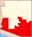
File:Diocese of Tuscon Map.png
Appearance
Diocese_of_Tuscon_Map.png (351 × 407 pixels, file size: 7 KB, MIME type: image/png)
File history
Click on a date/time to view the file as it appeared at that time.
| Date/Time | Thumbnail | Dimensions | User | Comment | |
|---|---|---|---|---|---|
| current | 13:19, 30 May 2018 |  | 351 × 407 (7 KB) | Farragutful | adjusted color |
| 10:10, 17 February 2015 |  | 351 × 407 (7 KB) | Sumiaz | Added Navajo/Hopi Nations and county borders for Phoenix Diocese map | |
| 09:34, 17 February 2015 |  | 351 × 407 (6 KB) | Sumiaz | Error in previous upload | |
| 09:29, 17 February 2015 |  | 351 × 407 (6 KB) | Sumiaz | Fixed border | |
| 09:27, 17 February 2015 |  | 432 × 407 (6 KB) | Sumiaz | Removed Gila River Indian Community portion from Pinal County | |
| 19:06, 26 September 2012 |  | 351 × 407 (10 KB) | Farragutful | User created page with UploadWizard |
File usage
The following page uses this file:
Global file usage
The following other wikis use this file:
- Usage on de.wikipedia.org
- Usage on es.wikipedia.org
- Usage on fr.wikipedia.org
- Usage on id.wikipedia.org
- Usage on it.wikipedia.org
- Usage on jv.wikipedia.org
- Usage on no.wikipedia.org
- Usage on ru.wikipedia.org
- Usage on www.wikidata.org

