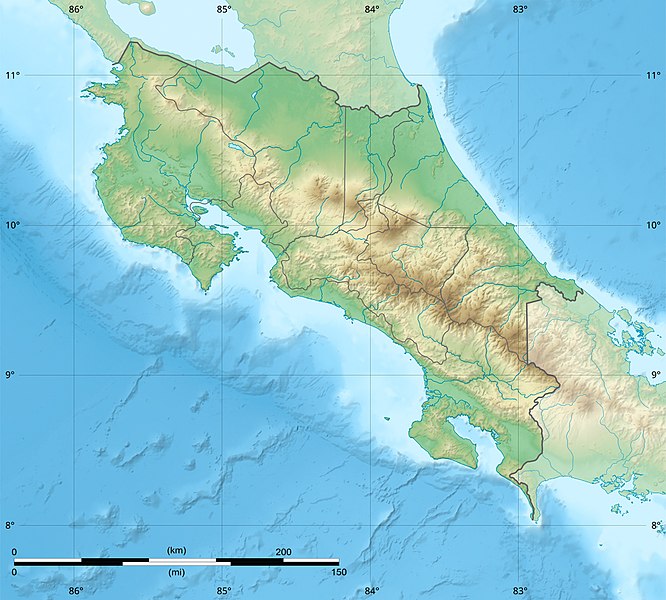
File:Costa Rica relief location map.jpg
Appearance

Size of this preview: 666 × 600 pixels. Other resolutions: 267 × 240 pixels | 533 × 480 pixels | 853 × 768 pixels | 1,148 × 1,034 pixels.
Original file (1,148 × 1,034 pixels, file size: 841 KB, MIME type: image/jpeg)
File history
Click on a date/time to view the file as it appeared at that time.
| Date/Time | Thumbnail | Dimensions | User | Comment | |
|---|---|---|---|---|---|
| current | 22:51, 30 March 2022 |  | 1,148 × 1,034 (841 KB) | Sting | New map using new data |
| 01:32, 4 November 2021 |  | 1,148 × 1,034 (906 KB) | RoboQwezt0x7CB | hand edited to remove non-existing waterbodies, used lower elevation green shade to bucket fill (best I can do without the tools to generate the map) particulary in the south of the country (probably an altitude render/clipping error), kept some that are hydroelectric plant's reservoirs | |
| 12:11, 19 July 2010 |  | 1,148 × 1,034 (500 KB) | Sting | Color profile | |
| 15:05, 30 July 2008 |  | 1,148 × 1,034 (491 KB) | Sting | - border | |
| 14:40, 13 June 2008 |  | 1,148 × 1,034 (499 KB) | Sting | Several improvements | |
| 01:21, 12 June 2008 |  | 1,148 × 1,034 (501 KB) | Sting | Correction on shaded layer | |
| 01:09, 12 June 2008 |  | 1,148 × 1,034 (504 KB) | Sting | == Summary == {{Location|10|00|00|N|84|00|00|W|scale:2000000}} <br/> {{Information |Description={{en|Blank relief map of Costa Rica for geo-location purpose.<br/>''Note :'' The ''Isla del Coco'', out of the map, is not shown.<br/>Scale |
File usage
More than 100 pages use this file. The following list shows the first 100 pages that use this file only. A full list is available.
- 1991 Limon earthquake
- 2017 Costa Rica earthquake
- Abangares River
- Aguas Zarcas volcanic field
- Alberto Manuel Brenes Biological Reserve
- Aranjuez River
- Arenal Volcano
- Arenal Volcano Emergency Forest Reserve
- Arenal Volcano National Park
- Barbilla National Park
- Barra Honda National Park
- Barranca River
- Barva Volcano
- Braulio Carrillo National Park
- Cahuita National Park
- Camaronal Wildlife Refuge
- Carara National Park
- Carrillo Airport
- Caño Negro Wildlife Refuge
- Cerro Cedral
- Cerro Chirripó
- Cerro Kamuk
- Cerro Tilarán
- Cerro de la Muerte
- Chato Volcano
- Corcovado National Park
- Costa Rica Open
- Costa Rican Central Valley
- Coto Colorado River
- Craugastor phasma
- Craugastor taurus
- Curi Cancha Wildlife Refuge
- Curré Formation
- Diriá National Park
- Geography of Costa Rica
- Golfo Dulce, Costa Rica
- Guacimal River
- Guanacaste National Park (Costa Rica)
- Guácimo and Pococí Protected Zone
- Guápiles Airport
- Horizontes Experimental Forest
- Irazú Volcano
- Irazú Volcano National Park
- Isla del Caño
- Isthmohyla xanthosticta
- Jesús María River
- Juan Castro Blanco National Park
- La Cangreja National Park
- La Selva Biological Station
- Lagarto River
- Laguna Las Camelias Wildlife Refuge
- Laguna Poco Sol
- Lake Arenal
- Lake Cachí
- Las Baulas Marine National Park
- Limón Group
- List of fossiliferous stratigraphic units in Central America
- Los Quetzales National Park
- Manuel Antonio National Park
- Maquenque National Wildlife Refuge
- Mata Redonda Wildlife Refuge
- Miravalles Jorge Manuel Dengo National Park
- Miravalles Volcano
- Moin Formation
- Monteverde Cloud Forest Reserve
- Negritos Islands Biological Reserve
- Nosara River
- Ochomogo War
- Orosí Volcano
- Ostional Mixed Wildlife Refuge
- Paso Real Formation, Costa Rica
- Piedras Blancas National Park
- Pirris River
- Platanar Volcano
- Poás Volcano
- Poás Volcano National Park
- Reventazón Dam
- Reventazón River
- Rincón de la Vieja National Park
- Rincón de la Vieja Volcano
- Río Banano Formation
- San José, Costa Rica
- San Lucas Island
- Savegre River
- Sierpe River
- Telire River
- Tempisque River
- Tenorio Volcano National Park
- Tortuguero National Park
- Tortuguero Protected Zone
- Turrialba Volcano
- Turrialba Volcano National Park
- Térraba River
- User:Ty654/List of earthquakes from 1900-1949 exceeding magnitude 7+
- User:Ty654/List of earthquakes from 1920-1929 exceeding magnitude 6+
- User:Ty654/List of earthquakes from 1930-1939 exceeding magnitude 6+
- User:Ty654/List of earthquakes from 1940-1949 exceeding magnitude 6+
- User:Ty654/List of earthquakes from 1950-1954 exceeding magnitude 6+
- User:Ty654/List of earthquakes from 1950-1999 exceeding magnitude 7+
- User:Ty654/List of earthquakes from 2000-present exceeding magnitude 7+
View more links to this file.
Global file usage
The following other wikis use this file:
- Usage on ar.wikipedia.org
- Usage on ast.wikipedia.org
- Usage on azb.wikipedia.org
- Usage on az.wikipedia.org
- Usage on ban.wikipedia.org
- Usage on ba.wikipedia.org
- Usage on be.wikipedia.org
- Usage on bg.wikipedia.org
- Usage on bn.wikipedia.org
- Usage on bs.wikipedia.org
- Usage on ca.wikipedia.org
- Usage on ceb.wikipedia.org
- Usage on ce.wikipedia.org
- Usage on ckb.wikipedia.org
- Usage on cs.wikipedia.org
View more global usage of this file.


