Jump to content

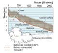
File:Coropuna ice profile.png

Page contents not supported in other languages.
This is a file from the Wikimedia Commons
From Wikipedia, the free encyclopedia

Original file (890 × 813 pixels, file size: 499 KB, MIME type: image/png)

Summary

Description
English: Example of interpreted profile of transect 2 from the GPR on the slope to the summit - see File:Radar profile and glacier evolution Coropuna for the profile in question.
Date
Source

[http://www.the-cryosphere.net/4/313/2010/tc-4-313-2010.pdf Assessing high altitude glacier thickness, volume and area changes using field, GIS and remote sensing techniques:

the case of Nevado Coropuna (Peru)]
Author P. Peduzzi, C. Herold, and W. Silverio
Other versions

Licensing

w:en:Creative Commons
attribution
This file is licensed under the Creative Commons Attribution 3.0 Unported license.
You are free:
  • to share – to copy, distribute and transmit the work
  • to remix – to adapt the work
Under the following conditions:
  • attribution – You must give appropriate credit, provide a link to the license, and indicate if changes were made. You may do so in any reasonable manner, but not in any way that suggests the licensor endorses you or your use.

Captions

Add a one-line explanation of what this file represents

Items portrayed in this file

depicts

23 August 2010

image/png

727bff3b13308dfbdde737337e0848a898956039

511,159 byte

813 pixel

890 pixel

File history

Click on a date/time to view the file as it appeared at that time.

Date/TimeThumbnailDimensionsUserComment
current18:00, 18 October 2019Thumbnail for version as of 18:00, 18 October 2019890 × 813 (499 KB)Jo-Jo EumerusLarger image
15:59, 26 February 2016Thumbnail for version as of 15:59, 26 February 2016372 × 360 (63 KB)Jo-Jo EumerusUser created page with UploadWizard

The following page uses this file: