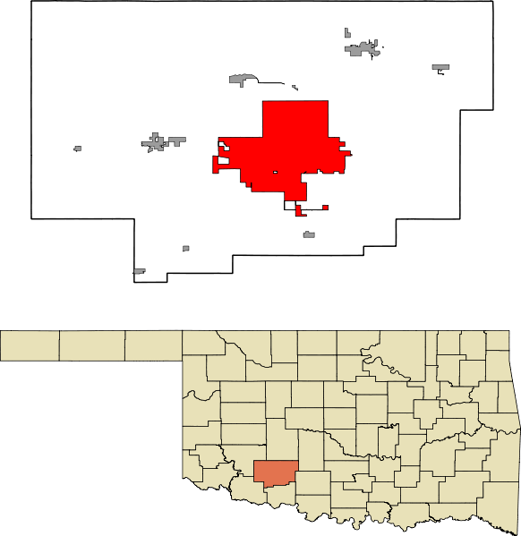
File:Comanche County Oklahoma Incorporated areas highlighting Lawton.svg
Appearance

Size of this PNG preview of this SVG file: 582 × 599 pixels. Other resolutions: 233 × 240 pixels | 466 × 480 pixels | 746 × 768 pixels | 995 × 1,024 pixels | 1,990 × 2,048 pixels.
Original file (SVG file, nominally 582 × 599 pixels, file size: 801 KB)
File history
Click on a date/time to view the file as it appeared at that time.
| Date/Time | Thumbnail | Dimensions | User | Comment | |
|---|---|---|---|---|---|
| current | 07:47, 13 October 2011 |  | 582 × 599 (801 KB) | Crimsonedge34 | Margins |
| 06:49, 13 October 2011 |  | 692 × 646 (727 KB) | Crimsonedge34 | Would help if I uploaded the correct map. | |
| 06:48, 13 October 2011 |  | 1,052 × 744 (42 KB) | Crimsonedge34 | {{Information |Description ={{en|1=A map highlighting the city of Lawton in Comanche County in the US state of Oklahoma. Based on similar maps from Ixnayonthetimmay}} |Source ={{own}} |Author =[[User:Crimso |
File usage
The following page uses this file:
Global file usage
The following other wikis use this file:
- Usage on ar.wikipedia.org
- Usage on arz.wikipedia.org
- Usage on azb.wikipedia.org
- Usage on br.wikipedia.org
- Usage on ca.wikipedia.org
- Usage on eu.wikipedia.org
- Usage on fa.wikipedia.org
- Usage on fi.wikipedia.org
- Usage on fr.wikipedia.org
- Usage on ga.wikipedia.org
- Usage on gd.wikipedia.org
- Usage on glk.wikipedia.org
- Usage on ht.wikipedia.org
- Usage on hu.wikipedia.org
- Usage on ia.wikipedia.org
- Usage on id.wikipedia.org
- Usage on kw.wikipedia.org
- Usage on no.wikipedia.org
- Usage on pt.wikipedia.org
- Usage on sh.wikipedia.org
- Usage on simple.wikipedia.org
- Usage on sr.wikipedia.org
- Usage on sv.wikipedia.org
- Usage on tr.wikipedia.org
- Usage on tt.wikipedia.org
- Usage on ur.wikipedia.org
- Usage on vo.wikipedia.org
- Usage on www.wikidata.org
- Usage on zh.wikipedia.org
