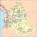
File:Columbia dams map.png
Appearance

Size of this preview: 599 × 600 pixels. Other resolutions: 240 × 240 pixels | 479 × 480 pixels | 767 × 768 pixels | 1,205 × 1,207 pixels.
Original file (1,205 × 1,207 pixels, file size: 414 KB, MIME type: image/png)
File history
Click on a date/time to view the file as it appeared at that time.
| Date/Time | Thumbnail | Dimensions | User | Comment | |
|---|---|---|---|---|---|
| current | 19:37, 18 November 2008 |  | 1,205 × 1,207 (414 KB) | Kmusser | Re-categorized utility dams into public and private, added Brilliant Dam, made main-stem dams larger. |
| 18:49, 3 November 2008 |  | 1,209 × 1,213 (417 KB) | Kmusser | Thinned out labels, added adjacent basins. Still to do: revise categorization. | |
| 00:32, 18 October 2008 |  | 1,365 × 1,369 (480 KB) | Kmusser | spelling | |
| 18:03, 16 October 2008 |  | 1,368 × 1,374 (482 KB) | Kmusser | darkened dam labels | |
| 18:50, 15 October 2008 |  | 1,371 × 1,380 (481 KB) | Kmusser | {{Information |Description=This is a map of the dams within the Columbia River drainage basin. |Source=self-made, based on National Atlas and [[:en:Digital Chart of the World|Digital Chart |
File usage
The following 3 pages use this file:
Global file usage
The following other wikis use this file:
- Usage on bg.wikipedia.org
- Usage on fr.wikipedia.org
- Usage on ja.wikipedia.org
- Usage on nl.wikipedia.org
- Usage on ru.wikipedia.org
- Usage on uk.wikipedia.org

