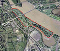
File:Columbia Island - aerial view 2005.jpg
Appearance
Columbia_Island_-_aerial_view_2005.jpg (473 × 406 pixels, file size: 240 KB, MIME type: image/jpeg)
File history
Click on a date/time to view the file as it appeared at that time.
| Date/Time | Thumbnail | Dimensions | User | Comment | |
|---|---|---|---|---|---|
| current | 18:23, 6 May 2013 |  | 473 × 406 (240 KB) | Tim1965 | {{Information |Description ={{en|1=Aerial view of Columbia Island (outlined in red) in the Potomac River in Washington, D.C., in the United States. Arlington Memorial Bridge enters the island from the northeast, connecting it to the Lincoln Memoria... |
File usage
The following page uses this file:
Global file usage
The following other wikis use this file:
- Usage on ceb.wikipedia.org
- Usage on fr.wikipedia.org
- Usage on he.wikipedia.org
- Usage on ur.wikipedia.org
- Usage on www.wikidata.org


