File:Chowanrivermap.png
Appearance
Chowanrivermap.png (500 × 417 pixels, file size: 156 KB, MIME type: image/png)
File history
Click on a date/time to view the file as it appeared at that time.
| Date/Time | Thumbnail | Dimensions | User | Comment | |
|---|---|---|---|---|---|
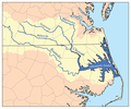
| current | 18:53, 9 February 2007 |  | 500 × 417 (156 KB) | Kmusser | This is a map of eastern portion of the Chowan/Roanoke watershed, showing the Chowan, Meherrin, Nottoway and Blackwater rivers as well as Albemarle Sound. For the western portion of the watershed see [[:Image:Ro |
File usage
The following 8 pages use this file:
Global file usage
The following other wikis use this file:
- Usage on arz.wikipedia.org
- Usage on bg.wikipedia.org
- Usage on ceb.wikipedia.org
- Usage on de.wikipedia.org
- Usage on es.wikipedia.org
- Usage on fr.wikipedia.org
- Usage on hu.wikipedia.org
- Usage on ja.wikipedia.org
- Usage on nl.wikipedia.org
- Usage on pl.wikipedia.org
- Usage on pt.wikipedia.org
- Usage on ru.wikipedia.org
- Usage on sr.wikipedia.org
- Usage on www.wikidata.org

