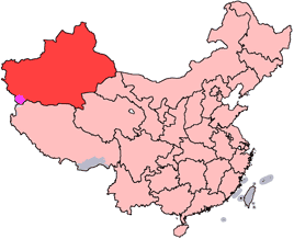
File:China-Xinjiang.png
Appearance
China-Xinjiang.png (268 × 218 pixels, file size: 16 KB, MIME type: image/png)
File history
Click on a date/time to view the file as it appeared at that time.
| Date/Time | Thumbnail | Dimensions | User | Comment | |
|---|---|---|---|---|---|
| current | 14:44, 15 July 2005 |  | 268 × 218 (16 KB) | Schaengel89~commonswiki | transparent background |
| 22:40, 4 June 2005 |  | 268 × 218 (9 KB) | Ran | '''en''': Location of Xinjiang Uyghur Autonomous Region in the People's Republic of China. See Category:Locator maps of province-level divisions of the People's Republic of China for more information. '''zh''': 新疆維吾爾自治區在中華人� |
File usage
More than 100 pages use this file. The following list shows the first 100 pages that use this file only. A full list is available.
- Anningqu
- Aral, Xinjiang
- Awat County
- Ayding Lake
- Aykol
- Baijiantan, Karamay
- Baluntai
- Bedel Pass
- Beidaqu Township
- Beyik Pass
- Bogda Peak
- Bogda Shan
- Bohu County
- Bole, Xinjiang
- Bolor-Tagh
- Borhoi Township
- Bosten Lake
- Bukadaban Feng
- Chaiwopu Lake
- Changji
- Chongtar Kangri
- Dahongliutan
- Dushanzi, Karamay
- Dzungarian Alatau
- Ebi Lake
- Emin Valley
- Fuyun County
- Gongliu County
- Habahe County
- Hami Depression
- Hejing County
- Hotan River
- Hoxud County
- Hutubi County
- Jeminay County
- Jinghe County
- Kalaza Formation
- Karakul (Xinjiang)
- Karamay, Karamay
- Karatash River
- Koktokay
- Kulma Pass
- Luntai County
- Manas County
- Manasi River
- Melikawat
- Midong, Ürümqi
- Molcha River
- Mori Kazakh Autonomous County
- Mutou Valley
- Nilka County
- Orku, Karamay
- Qagan Qehe Township
- Qapqal Xibe Autonomous County
- Qiemo River
- Qigxin
- Qinggil County
- Qinggir
- Sarikol Range
- Sarpo Laggo Glacier
- Saybag, Ürümqi
- Sayram Lake
- Shaquanzi
- Shawan, Xinjiang
- Shuimogou, Ürümqi
- Shule County
- Sishilichengzi
- Subashi Temple
- Tacheng Prefecture
- Taghdumbash Pamir
- Tarbagatai Mountains
- Tashidian
- Tashkurgan River
- Tatrang
- The Crown (mountain)
- Tianshan, Ürümqi
- Todok
- Toli County
- Tomort
- Toutunhe, Ürümqi
- Tuman River
- Tuyoq valley
- Ulungur Lake
- Ulungur River
- Wenquan County
- Wuhaoqu Township
- Wujiaqu
- Wusu
- Xinhe County, Xinjiang
- Xinshi, Ürümqi
- Xinyuan County
- Xuelian Feng
- Yanqi Hui Autonomous County
- Yining County
- Yinsugaiti Glacier
- Yiwu County
- Yumin County
- Zangguy
- Zhaosu County
- Ürümqi County
View more links to this file.
Global file usage
The following other wikis use this file:
- Usage on ar.wikipedia.org
- Usage on da.wikipedia.org
- Usage on de.wikipedia.org
- Mongolen
- Xinjiang
- Uiguren
- Kasachen
- Usbeken
- Mandschu
- Kirgisen
- Tuwiner
- Oiraten
- Han (Ethnie)
- Hui-Chinesen
- Bonan
- Kalmücken
- Dongxiang
- Xibe
- Daur
- Salar
- Yugur
- Tu (Volk)
- Abdal (Xinjiang)
- Tadschiken Chinas
- Russische Minderheit in China
- Diskussion:Uiguren/Archiv/1
- Tataren Chinas
- Vorlage:Navigationsleiste Nationalitäten in Xinjiang
- Geschichte der Uiguren
- Ili-Türken
- Usage on de.wikinews.org
- Usage on dsb.wikipedia.org
- Usage on eo.wikinews.org
- Usage on fr.wikipedia.org
View more global usage of this file.


