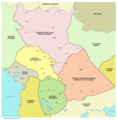
File:Central balkans 1373 1395.png
Appearance

Size of this preview: 591 × 599 pixels. Other resolutions: 237 × 240 pixels | 473 × 480 pixels | 757 × 768 pixels | 1,010 × 1,024 pixels | 2,019 × 2,048 pixels | 2,600 × 2,637 pixels.
Original file (2,600 × 2,637 pixels, file size: 249 KB, MIME type: image/png)
File history
Click on a date/time to view the file as it appeared at that time.
| Date/Time | Thumbnail | Dimensions | User | Comment | |
|---|---|---|---|---|---|
| current | 19:00, 10 December 2011 |  | 2,600 × 2,637 (249 KB) | WikiEditor2004 | aesthetics |
| 10:02, 12 January 2011 |  | 2,581 × 2,643 (248 KB) | WikiEditor2004 | Reverted to version as of 13:03, 10 March 2010 - it did according to my history atlas. borders in this map are same as in that atlas. if your sources are claiming something else then please draw and upload another map based on such sources | |
| 21:41, 11 January 2011 |  | 2,581 × 2,643 (312 KB) | Olahus | Serbia didn't border to Wallachia. | |
| 13:03, 10 March 2010 |  | 2,581 × 2,643 (248 KB) | WikiEditor2004 | Reverted to version as of 22:22, 8 March 2010 | |
| 22:56, 8 March 2010 |  | 1,500 × 1,500 (140 KB) | VízPart | much better version. please upload your own as separate | |
| 22:22, 8 March 2010 |  | 2,581 × 2,643 (248 KB) | WikiEditor2004 | Reverted to version as of 12:11, 8 March 2010 - please do not do that | |
| 21:40, 8 March 2010 |  | 1,500 × 1,500 (140 KB) | VízPart | better version | |
| 12:11, 8 March 2010 |  | 2,581 × 2,643 (248 KB) | WikiEditor2004 | Reverted to version as of 23:35, 13 January 2010 - rv - please upload your version as separate file, I do not agree with that colour change | |
| 02:18, 8 March 2010 |  | 1,500 × 1,500 (140 KB) | Ajdebre | improved | |
| 23:35, 13 January 2010 |  | 2,581 × 2,643 (248 KB) | WikiEditor2004 | improved version |
File usage
The following 13 pages use this file:
- Balšić noble family
- Battle of Pločnik
- Dejanović noble family
- Fall of the Serbian Empire
- Konstantin Dejanović
- Lordship of Prilep
- Ottoman Serbia
- Serbia in the Middle Ages
- Tvrtko I of Bosnia
- Vuk Branković
- Zeta under the Balšići
- User:Falcaorib/Serbia, Yugoslavia and Albania
- User:GerardM/Battles including the Ottoman Empire
Global file usage
The following other wikis use this file:
- Usage on ar.wikipedia.org
- Usage on arz.wikipedia.org
- Usage on azb.wikipedia.org
- Usage on az.wikipedia.org
- Usage on ba.wikipedia.org
- Usage on bg.wikipedia.org
- Usage on bs.wikipedia.org
- Usage on ca.wikipedia.org
- Usage on cs.wikipedia.org
- Usage on de.wikipedia.org
- Usage on el.wikipedia.org
- Usage on et.wikipedia.org
- Usage on fr.wikipedia.org
- Usage on gl.wikipedia.org
- Usage on hr.wikipedia.org
- Usage on id.wikipedia.org
- Usage on it.wikipedia.org
- Usage on ja.wikipedia.org
- Usage on lt.wikipedia.org
View more global usage of this file.


