File:Cascade Range geology detail.png
Appearance
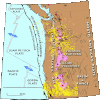
Cascade_Range_geology_detail.png (416 × 414 pixels, file size: 32 KB, MIME type: image/png)
File history
Click on a date/time to view the file as it appeared at that time.
| Date/Time | Thumbnail | Dimensions | User | Comment | |
|---|---|---|---|---|---|
| current | 18:17, 12 May 2013 |  | 416 × 414 (32 KB) | Hike395 | {{Information |Description ={{en|1=Detailed geological map of the Cascade Range and environs. Yellow rings indicate recorded earthquakes. Black lines show faults active within past 10,000 years.}} |Source =http://geomaps.wr.usgs.gov/parks/pr... |
File usage
No pages on the English Wikipedia use this file (pages on other projects are not listed).


