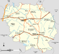
File:Carte de la Creuse.svg
Appearance

Size of this PNG preview of this SVG file: 655 × 599 pixels. Other resolutions: 262 × 240 pixels | 525 × 480 pixels | 839 × 768 pixels | 1,119 × 1,024 pixels | 2,238 × 2,048 pixels | 1,036 × 948 pixels.
Original file (SVG file, nominally 1,036 × 948 pixels, file size: 224 KB)
File history
Click on a date/time to view the file as it appeared at that time.
| Date/Time | Thumbnail | Dimensions | User | Comment | |
|---|---|---|---|---|---|
| current | 10:47, 10 October 2008 |  | 1,036 × 948 (224 KB) | LeMorvandiau | Remaniement général pour respect des conventions cartographiques Category:Maps of Creuse |
| 13:30, 28 August 2008 |  | 1,303 × 1,132 (210 KB) | LeMorvandiau | {{Information |Description={{fr|1=Carte du département français du Creuse avec ses réseaux hydrographique et routier principaux.}} |Source=travail personnel (own work) |Author=LeMorvandiau |Date=28 ao |
File usage
The following page uses this file:
Global file usage
The following other wikis use this file:
- Usage on br.wikipedia.org
- Usage on de.wikipedia.org
- Usage on el.wikipedia.org
- Usage on eo.wikipedia.org
- Usage on es.wikipedia.org
- Usage on eu.wikipedia.org
- Usage on fa.wikipedia.org
- Usage on fi.wikipedia.org
- Usage on fr.wikipedia.org
- Usage on fr.wikinews.org
- Usage on he.wikipedia.org
- Usage on hu.wikipedia.org
- Usage on ja.wikipedia.org
- Usage on mr.wikipedia.org
- Usage on nl.wikipedia.org
- Usage on pms.wikipedia.org
- Usage on pt.wikipedia.org
- Usage on ru.wikipedia.org
- Usage on simple.wikipedia.org
- Usage on sq.wikipedia.org

