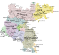
File:Carte de l'Ile de France.svg
Appearance

Size of this PNG preview of this SVG file: 647 × 600 pixels. Other resolutions: 259 × 240 pixels | 518 × 480 pixels | 828 × 768 pixels | 1,104 × 1,024 pixels | 2,209 × 2,048 pixels | 2,627 × 2,436 pixels.
Original file (SVG file, nominally 2,627 × 2,436 pixels, file size: 1.48 MB)
File history
Click on a date/time to view the file as it appeared at that time.
| Date/Time | Thumbnail | Dimensions | User | Comment | |
|---|---|---|---|---|---|
| current | 08:46, 28 April 2024 |  | 2,627 × 2,436 (1.48 MB) | Vaulxnoy | Reverted to version as of 17:24, 27 April 2024 (UTC) L'expression Picardie française est utilisée par certains cartographes pour désigner la partie du Gouvernement militaire de l'IDF ne se confondant pas dans la province. C'est une nuance qu'il est raisonnable de préciser ici. Retour à la version précédente. |
| 07:14, 28 April 2024 |  | 2,627 × 2,436 (1.48 MB) | Francili | Reverted to version as of 03:50, 12 May 2013 (UTC) L’utilisation des termes « Picardie française » sur une carte de Sanson datée de 1722 est discutable puisqu’à cette date Beauvaisis, Noyonnais, Soissonnais, Laonnois, … rattachés un temps à la ceinture défensive constituée du Calaisis à la Thiérache autour des Flandres et de l'Artois espagnols, ou gouvernement militaire dit de Picardie, sont retournés à l’île de France, lorsque le royaume de France contrôle de nouveau l'Artois fin 1641. Les l... | |
| 17:24, 27 April 2024 |  | 2,627 × 2,436 (1.48 MB) | Vaulxnoy | Reverted to version as of 18:47, 19 January 2024 (UTC) | |
| 16:57, 27 April 2024 |  | 2,627 × 2,436 (1.48 MB) | Francili | Reverted to version as of 14:29, 19 January 2024 (UTC) | |
| 18:47, 19 January 2024 |  | 2,627 × 2,436 (1.48 MB) | Vaulxnoy | L'expression Picardie française est historiquement employée pour qualifier cette zone, et est présente sur la carte de Sanson indiquée en description, que vous auriez consultée si vous faisiez les choses attentivement, je vous mets le lien ici afin que vous n'ayez plus d'excuse : https://gallica.bnf.fr/ark:/12148/btv1b8444388s/f1.item.zoom | |
| 14:29, 19 January 2024 |  | 2,627 × 2,436 (1.48 MB) | CampagnardDeter | La "Picardie française" est un concept, tout du moins une expression, totalement inventée Reverted to version as of 20:15, 17 January 2024 (UTC) | |
| 02:04, 19 January 2024 |  | 2,627 × 2,436 (1.48 MB) | Vaulxnoy | Reverted to version as of 17:10, 11 July 2023 (UTC) | |
| 20:15, 17 January 2024 |  | 2,627 × 2,436 (1.48 MB) | CampagnardDeter | Reverted to version as of 03:50, 12 May 2013 (UTC) | |
| 17:10, 11 July 2023 |  | 2,627 × 2,436 (1.48 MB) | Vaulxnoy | Rajout d'informations sur le nord du gouvernement. | |
| 03:50, 12 May 2013 |  | 2,627 × 2,436 (1.48 MB) | Oie blanche | User created page with UploadWizard |
File usage
The following page uses this file:
Global file usage
The following other wikis use this file:
- Usage on br.wikipedia.org
- Usage on de.wikipedia.org
- Usage on el.wikipedia.org
- Usage on es.wikipedia.org
- Usage on fr.wikipedia.org
- Usage on fr.wiktionary.org
- Usage on it.wikipedia.org
- Usage on ja.wikipedia.org
- Usage on ko.wikipedia.org
- Usage on vls.wikipedia.org
- Usage on zh.wikipedia.org
