Jump to content

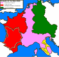
File:Carolingian empire 843.svg

Page contents not supported in other languages.
This is a file from the Wikimedia Commons
From Wikipedia, the free encyclopedia

Original file (SVG file, nominally 1,091 × 1,053 pixels, file size: 308 KB)

Summary

Description
Español: Imperio carolingio tras el Tratado de Verdún (843)
Date
Source

Own work

  • [1]: The clearest division was that along the Loire, cutting off the more Frankish Neustria and Austrasia from the more Romanized Aquitaine. This division had already been recognized in Charlemagne's day, for he had established Aquitaine as a sub-kingdom for his son Louis the Pious; when Charles the Bald obtained West Francia, Aquitaine was in hands of his nephew Pippin II, whose reluctance to recognize his uncle lent new sharpness to the old ethnic division. In fact Charles spent much of his reign striving for mastery south of the Loire; and though he was ultimately successful in 855
  • [2]: Pepin II, son and successor of Pepin I, had to struggle for the possession of his kingdom with his uncle Charles le Chauve, by whom he was deposed after a long contest which was maintained with various fluctuations of success, during which the people of Aquitaine shifted their allegiance with wonderful facility.
  • [3]: Charles eut l'ancienne Neustrie et la partie de la Gaule qui n'était point donnée à Lothaire. Dans celle partie, se trouvait comprise l'Aquitaine qu'il lui fallait soumettre , et la Bretagne qu'il devait conquérir, s'il désirait y obtenir une domination réelle.
  • [4]: En Verdun, en 843, se hizo otra distribución: á saber, á Lotario Italia, Provenza, Delfinado, Saboya, Suiza Francesa, Franco Condado, la Borgoña al Este del Saona, la Alsacia, la Lorena, el Cambresis, y cuanto hay entre el Rhin, el Escalda, y el Mosa, excepto Spira, Worms, Maguncia, Ingelheim; luego sobre la derecha del Rhin desde Bonn hasta la Frisia, la antigua Francia Ripuaria desde el Rhin á la Sajonia; añadiendo sobre la derecha del Ródano el Lionés, el Vivarais y el Uzige. Tocó á Luis el Germánico la Francia Transriniana con Worms, Spira, Maguncia, Ingelhein, y por esto se le disminuyeron la Frisia, y la parte de Francia Ripuaria dadas al precedente. A Carlos el Calvo le correspondió la Francia Occidental, es decir, los países al Occidente del Escalda, del Mosa, del Saona, y del Ródano, hasta los dos mares que fueron los confines que conservó Francia hasta el siglo XIV.
  • [5]: Lothair was quite ready to sacrifice his nephew, consequently he offered Charles the dominions of Pepin,—Aquitaine, together with Septimania, Provence and ten counties between Seine and Loire.
  • [6]: Pepin I left a son of the same name as himself, but Lois set aside his claims in favour of Charles the Bald. Pepin II, however, was proclaimed king by a faction in Aquitaine, and was effectively ruler of part of the country from 839 to 852.
Author Trasamundo
Other versions

[edit]

SVG development
InfoField
 
The SVG code is valid.
 
This map was created with Inkscape, or with something else.

Licensing

I, the copyright holder of this work, hereby publish it under the following licenses:
GNU head Permission is granted to copy, distribute and/or modify this document under the terms of the GNU Free Documentation License, Version 1.2 or any later version published by the Free Software Foundation; with no Invariant Sections, no Front-Cover Texts, and no Back-Cover Texts. A copy of the license is included in the section entitled GNU Free Documentation License.
w:en:Creative Commons
attribution share alike
This file is licensed under the Creative Commons Attribution-Share Alike 3.0 Unported, 2.5 Generic, 2.0 Generic and 1.0 Generic license.
You are free:
  • to share – to copy, distribute and transmit the work
  • to remix – to adapt the work
Under the following conditions:
  • attribution – You must give appropriate credit, provide a link to the license, and indicate if changes were made. You may do so in any reasonable manner, but not in any way that suggests the licensor endorses you or your use.
  • share alike – If you remix, transform, or build upon the material, you must distribute your contributions under the same or compatible license as the original.
You may select the license of your choice.

Captions

Add a one-line explanation of what this file represents

Items portrayed in this file

depicts

13 March 2010

image/svg+xml

cde6cb77710cc5f8b9dfbb5af493a3dfd6ba0c74

315,434 byte

1,053 pixel

1,091 pixel

File history

Click on a date/time to view the file as it appeared at that time.

Date/TimeThumbnailDimensionsUserComment
current21:10, 9 December 2016Thumbnail for version as of 21:10, 9 December 20161,091 × 1,053 (308 KB)RowanwindwhistlerLarger text in legend. Fake text added for better rendering in Wikipedia.
20:29, 4 May 2016Thumbnail for version as of 20:29, 4 May 20161,091 × 1,053 (220 KB)RowanwindwhistlerClear shapes, some colours from https://en.wikipedia.org/wiki/Wikipedia:WikiProject_Maps/Conventions Softer colours form http://colorbrewer2.org/
18:36, 13 March 2010Thumbnail for version as of 18:36, 13 March 20101,091 × 1,053 (1.02 MB)Trasamundolegend
18:32, 13 March 2010Thumbnail for version as of 18:32, 13 March 20101,091 × 1,053 (1.02 MB)Trasamundo{{Information |Description={{es|1=Imperio carolingio tras el Tratado de Verdún (843)}} |Source={{own}} |Author=Trasamundo |Date=13 March 2010 |Permission= |other_versions= }}

Global file usage

Metadata