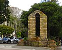
File:Carmel-by-the-Sea World War I Memorial Arch.jpg

Original file (4,000 × 2,150 pixels, file size: 7.59 MB, MIME type: image/jpeg)
| This is a file from the Wikimedia Commons. Information from its description page there is shown below. Commons is a freely licensed media file repository. You can help. |
Summary
| DescriptionCarmel-by-the-Sea World War I Memorial Arch.jpg |
English: Carmel-by-the-Sea, often simply called Carmel, is a city in Monterey County, California, United States, founded in 1902 and incorporated on October 31, 1916. Situated on the Monterey Peninsula, Carmel is known for its natural scenery and rich artistic history. In 1906, the San Francisco Call devoted a full page to the "artists, writers and poets at Carmel-by-the-Sea", and in 1910 it reported that 60 percent of Carmel's houses were built by citizens who were "devoting their lives to work connected to the aesthetic arts." Early City Councils were dominated by artists, and the city has had several mayors who were poets or actors, including Herbert Heron, founder of the Forest Theater, bohemian writer and actor Perry Newberry, and actor-director Clint Eastwood.
The city is known for being dog-friendly, with numerous hotels, restaurants and retail establishments admitting guests with dogs. Carmel is also known for several unusual laws, including a prohibition on wearing high-heel shoes without a permit, enacted to prevent lawsuits arising from tripping accidents caused by irregular pavement. Carmel-by-the-Sea is located on the Pacific coast, about 330 miles (530 km) north of Los Angeles and 120 miles (190 km) south of San Francisco. Communities near Carmel-by-the-Sea include Carmel Valley and Carmel Highlands. As of the 2010 census, the town had a total population of 3,722, down from 4,081 at the 2000 census. en.wikipedia.org/wiki/Carmel-by-the-Sea,_California en.wikipedia.org/wiki/Wikipedia:Text_of_Creative_Commons_... |
|||
| Date | Taken on 28 March 2016, 16:06:04 | |||
| Source | https://www.flickr.com/photos/kenlund/25522868594/ | |||
| Author | Ken Lund | |||
| Other versions |
|
| Camera location | 36° 33′ 18.64″ N, 121° 55′ 18.8″ W | View this and other nearby images on: OpenStreetMap |
|---|
Licensing
- You are free:
- to share – to copy, distribute and transmit the work
- to remix – to adapt the work
- Under the following conditions:
- attribution – You must give appropriate credit, provide a link to the license, and indicate if changes were made. You may do so in any reasonable manner, but not in any way that suggests the licensor endorses you or your use.
- share alike – If you remix, transform, or build upon the material, you must distribute your contributions under the same or compatible license as the original.
| This image was originally posted to Flickr by Ken Lund at https://flickr.com/photos/75683070@N00/25522868594. It was reviewed on 16 March 2022 by FlickreviewR 2 and was confirmed to be licensed under the terms of the cc-by-sa-2.0. |
16 March 2022
Captions
Items portrayed in this file
depicts
some value
28 March 2016
36°33'18.641"N, 121°55'18.804"W
0.004 second
4.5
11.2 millimetre
image/jpeg
c828d98fda2739bc37cbfd10bfefa12b3b813e10
7,953,529 byte
2,150 pixel
4,000 pixel
File history
Click on a date/time to view the file as it appeared at that time.
| Date/Time | Thumbnail | Dimensions | User | Comment | |
|---|---|---|---|---|---|
| current | 19:37, 16 March 2022 |  | 4,000 × 2,150 (7.59 MB) | Greghenderson2006 | Uploaded a work by Ken Lund from https://www.flickr.com/photos/kenlund/25522868594/ with UploadWizard |
File usage
Metadata
This file contains additional information, probably added from the digital camera or scanner used to create or digitize it.
If the file has been modified from its original state, some details may not fully reflect the modified file.
| Camera manufacturer | Canon |
|---|---|
| Camera model | Canon PowerShot SX280 HS |
| Exposure time | 1/250 sec (0.004) |
| F-number | f/4.5 |
| ISO speed rating | 80 |
| Date and time of data generation | 16:06, 28 March 2016 |
| Lens focal length | 11.2 mm |
| Latitude | 36° 33′ 18.64″ N |
| Longitude | 121° 55′ 18.8″ W |
| Horizontal resolution | 180 dpi |
| Vertical resolution | 180 dpi |
| File change date and time | 16:06, 28 March 2016 |
| Y and C positioning | Centered |
| Exif version | 2.3 |
| Date and time of digitizing | 16:06, 28 March 2016 |
| Meaning of each component |
|
| Shutter speed | 7.9715435469963 |
| APEX aperture | 4.3398500267809 |
| Exposure bias | −0.33333333333333 |
| Maximum land aperture | 4.3398500267809 APEX (f/4.5) |
| Metering mode | Pattern |
| Flash | Flash did not fire, compulsory flash suppression |
| Supported Flashpix version | 1 |
| Color space | sRGB |
| Focal plane X resolution | 16,393.442622951 |
| Focal plane Y resolution | 16,393.442622951 |
| Focal plane resolution unit | inches |
| Sensing method | One-chip color area sensor |
| File source | Digital still camera |
| Custom image processing | Custom process |
| Exposure mode | Manual exposure |
| White balance | Auto white balance |
| Digital zoom ratio | 1 |
| Scene capture type | Standard |
| GPS time (atomic clock) | 23:06 |
| Receiver status | Measurement in progress |
| Geodetic survey data used | WGS-84 |
| GPS date | 28 March 2016 |
| GPS tag version | 0.0.3.2 |
| Rating (out of 5) | 0 |

