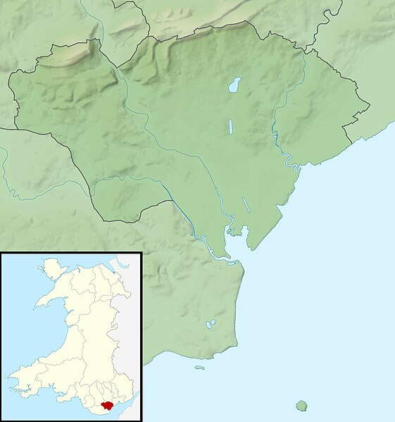
File:Cardiff UK relief location map.jpg
Appearance

Size of this preview: 561 × 599 pixels. Other resolutions: 225 × 240 pixels | 450 × 480 pixels | 719 × 768 pixels | 959 × 1,024 pixels | 2,010 × 2,146 pixels.
Original file (2,010 × 2,146 pixels, file size: 254 KB, MIME type: image/jpeg)
File history
Click on a date/time to view the file as it appeared at that time.
| Date/Time | Thumbnail | Dimensions | User | Comment | |
|---|---|---|---|---|---|
| current | 00:56, 30 November 2011 |  | 2,010 × 2,146 (254 KB) | Nilfanion | {{Information |Description=Relief map of Cardiff, UK. Equirectangular map projection on WGS 84 datum, with N/S stretched 160% Geographic limits: *West: 3.35W *East: 3.05W *North: 51.57N *South: 51.37N |Source=[[w:Ordnance Survey|Ordnance S |
File usage
The following 22 pages use this file:
- 19 High Street, Llandaff
- 2-4 High Street, Llandaff
- 6 High Street, Llandaff
- Animal Wall
- Bishop's Palace, Llandaff
- Caer Castell Camp
- Craig-y-parc House
- Hayes Island Snack Bar
- Jackson Hall, Cardiff
- Lisvane Reservoir
- Llanishen Reservoir
- Morganstown Castle Mound
- Shah Jalal Mosque, Cardiff
- St Andrew, Llandaff
- St Cross, Llandaff
- St Fagans Castle
- St Padarn's Institute
- Twmpath Castle
- Ty Bronna
- Wenallt Camp
- Module:Location map/data/Wales Cardiff
- Module:Location map/data/Wales Cardiff/doc
Global file usage
The following other wikis use this file:
- Usage on ar.wikipedia.org
- Usage on ceb.wikipedia.org
- Usage on de.wikipedia.org
- Usage on el.wikipedia.org
- Usage on es.wikipedia.org
- Usage on fr.wikipedia.org
- Usage on he.wikipedia.org
- Usage on hu.wikipedia.org
- Usage on ja.wikipedia.org
- Usage on kn.wikipedia.org
- Usage on ko.wikipedia.org
- Usage on pl.wikipedia.org
- Usage on pl.wikibooks.org
- Usage on sh.wikipedia.org
- Usage on si.wikipedia.org
- Usage on tr.wikipedia.org
- Usage on tt.wikipedia.org
- Usage on war.wikipedia.org
- Usage on www.wikidata.org
- Usage on zh.wikipedia.org
