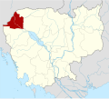
File:Cambodia Banteay Meanchey locator map.svg
Appearance

Size of this PNG preview of this SVG file: 664 × 600 pixels. Other resolutions: 266 × 240 pixels | 531 × 480 pixels | 850 × 768 pixels | 1,133 × 1,024 pixels | 2,267 × 2,048 pixels | 1,347 × 1,217 pixels.
Original file (SVG file, nominally 1,347 × 1,217 pixels, file size: 736 KB)
File history
Click on a date/time to view the file as it appeared at that time.
| Date/Time | Thumbnail | Dimensions | User | Comment | |
|---|---|---|---|---|---|
| current | 15:16, 8 June 2010 |  | 1,347 × 1,217 (736 KB) | Kmusser | {{Information |Description={{de|Positionskarte von Kambodscha}} Quadratische Plattkarte, N-S-Streckung 105 %. Geographische Begrenzung der Karte: * N: 14.8° N * S: 9.9° N * W: 102.2° O * O: 107.9° O {{en|Location map of [[:en:Cambod |
File usage
The following 80 pages use this file:
- Banteay Chhmar
- Banteay Meanchey province
- Banteay Neang
- Boeng Beng
- Bos Sbov
- Bát Tráng (Cambodia)
- Changha
- Chnuor Mean Chey
- Chob Vari
- Châmnaôm
- Kampong Svay, Banteay Meanchey
- Kaoh Pong Satv
- Koub
- Kouk Ballangk
- Kouk Kakthen
- Kouk Romiet
- Kumru, Cambodia
- Kuttasat
- Kôy Mêng
- Malai (commune)
- Malai district
- Mkak
- Mongkol Borey (town)
- Mongkol Borey district
- Nam Tau, Cambodia
- Nimit
- Or Prasat
- Ou Ambel
- Ou Beichoan Commune
- Ou Chrov district
- Ou Sampoar
- Ou Sralau
- Phkoam
- Phniet
- Phnom Dei Commune
- Phnom Srok (town)
- Phnom Srok district
- Phnum Lieb
- Phnum Toch
- Phum Thmei
- Poipet
- Poipet Municipality
- Ponley
- Poy Char
- Prasat, Preah Netr Preah
- Preah Netr Preah
- Preah Netr Preah (town)
- Preah Netr Preah district
- Preah Ponlea
- Rohal
- Rohat Tuek
- Roluos
- Ruessei Kraok
- Sambuor
- Samraong, Banteay Meanchey (commune)
- Sarongk
- Serei Saophoan (city)
- Serei Saophoan Municipality
- Sla Kram
- Soengh
- Souphi
- Spean Sraeng
- Srah Chik
- Srah Reang
- Svay Chek (commune)
- Svay Chek district
- Sœă
- Ta Baen
- Ta Kong
- Ta Lam
- Ta Phou
- Tean Kam
- Thma Puok (commune)
- Thma Puok district
- Treas
- Tuek Chour
- Tuek Thla, Banteay Meanchey
- Tuol Pongro
- Template:Banteay Meanchey province
- Category:Geography of Banteay Meanchey province
Global file usage
The following other wikis use this file:
- Usage on ar.wikipedia.org
- Usage on bg.wikipedia.org
- Usage on ceb.wikipedia.org
- Usage on eo.wikipedia.org
- Usage on fa.wikipedia.org
- Usage on fi.wikipedia.org
- Usage on frr.wikipedia.org
- Usage on fr.wikipedia.org
- Usage on hi.wikipedia.org
- Usage on id.wikipedia.org
- Usage on it.wikipedia.org
- Usage on ja.wikipedia.org
- Usage on km.wikipedia.org
- ខេត្តបន្ទាយមានជ័យ
- ស្រុកមង្គលបូរី
- ស្រុកភ្នំស្រុក
- ស្រុកព្រះនេត្រព្រះ
- ស្រុកអូរជ្រៅ
- ស្រុកសិរីសោភ័ណ
- ស្រុកថ្មពួក
- ស្រុកស្វាយចេក
- ស្រុកម៉ាឡៃ
- ទំព័រគំរូ:ខេត្តបន្ទាយមានជ័យ
- ឃុំបន្ទាយនាង
- ឃុំបត់ត្រង់
- ឃុំចំណោម
- ឃុំគោកបល្ល័ង្គ
- ឃុំគយម៉ែង
- ឃុំអូរប្រាសាទ
- ឃុំភ្នំតូច
- ឃុំរហាត់ទឹក
- ឃុំប្ញស្សីក្រោក
- ឃុំសំបួរ(ស្រុកមង្គលបូរី)
- ឃុំសឿ
- ឃុំស្រះរាំង
- ឃុំតាឡំ
- ឃុំណាំតៅ
- ឃុំប៉ោយចារ
- ឃុំពន្លៃ(ស្រុកភ្នំស្រុក)
- ឃុំស្ពានស្រែង
- ឃុំស្រះជីក
- ឃុំភ្នំដី
- ឃុំឈ្នួរមានជ័យ
- ឃុំជប់វារី
- ឃុំភ្នំលៀប
- ឃុំប្រាសាទ (ស្រុកព្រះនេត្រព្រះ)
View more global usage of this file.

