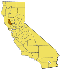
File:California map showing Lake County.png
Appearance
California_map_showing_Lake_County.png (200 × 231 pixels, file size: 22 KB, MIME type: image/png)
File history
Click on a date/time to view the file as it appeared at that time.
| Date/Time | Thumbnail | Dimensions | User | Comment | |
|---|---|---|---|---|---|
| current | 17:03, 1 July 2005 |  | 200 × 231 (22 KB) | Pyramide~commonswiki | Map of Lake county in California. From en: {{GFDL}} Category:Maps of counties in California |
File usage
The following 45 pages use this file:
- Adobe Creek (Lake County, California)
- Adobe Reservoir
- Buckingham Park, California
- Clear Lake Volcanic Field
- Clearlake Highlands, California
- Clearlake Park, California
- Dahnohabe, California
- Eastlake Landfill
- Finley, California
- Forbes Creek (California)
- Glenhaven, California
- Great Western Mine (Lake County, California)
- Guenoc, California
- Hidden Valley Lake (California)
- Highland Springs Reservoir
- Hopitsewah, California
- Hullville, California
- Jericho Creek (Hunting Creek tributary)
- Khawina, California
- Koi, California
- Lake Transit
- Lakeport Carnegie Library
- Lampson Field
- Little Blue Peak
- Loch Lomond, California
- Lolsel, California
- Lower Lake Community United Methodist Church
- Lower Lake Schoolhouse Museum
- Lower Lake Stone Jail
- Old Lake County Courthouse (California)
- Olposel, California
- Parramore Springs
- Pine Grove, Lake County, California
- Rattlesnake Island (Clear Lake)
- Seigler Canyon Creek
- St. Helena Toll Road and Bull Trail
- Stone House (Lake County, California)
- The Jams
- Thurston Lake
- Timber Lake (Lake County, California)
- Twin Pine Casino
- Upper Bohn Lake
- Whispering Pines, California
- Template:LakeCountyCA-geo-stub
- Draft:Robinson Rancheria Resort & Casino
Global file usage
The following other wikis use this file:
- Usage on bg.wikipedia.org
- Usage on li.wikipedia.org
- Usage on pam.wikipedia.org
- Usage on www.wikidata.org


