
File:Caliente Corridor.jpg

Size of this preview: 800 × 508 pixels. Other resolutions: 320 × 203 pixels | 640 × 407 pixels | 908 × 577 pixels.
Original file (908 × 577 pixels, file size: 162 KB, MIME type: image/jpeg)
| This is a file from the Wikimedia Commons. Information from its description page there is shown below. Commons is a freely licensed media file repository. You can help. |
Summary
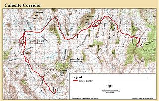
| Description | Map of the proposed Caliente Corridor route for transportation of spent nuclear fuel. (The northwest portion of the Amargosa Desert starts at the mountains at the southeast of the Sarcobatus Flat). |
| Date | 10/30/06 |
| Source | Office of Civilian Radioactive Waste Management, Department of Energy |
| Author | BSC Transportation |


Licensing
This work is in the public domain in the United States because it is a work prepared by an officer or employee of the United States Government as part of that person’s official duties under the terms of Title 17, Chapter 1, Section 105 of the US Code.
Note: This only applies to original works of the Federal Government and not to the work of any individual U.S. state, territory, commonwealth, county, municipality, or any other subdivision. This template also does not apply to postage stamp designs published by the United States Postal Service since 1978. (See § 313.6(C)(1) of Compendium of U.S. Copyright Office Practices). It also does not apply to certain US coins; see The US Mint Terms of Use.
|
 | |
| This file has been identified as being free of known restrictions under copyright law, including all related and neighboring rights. | ||
File history
Click on a date/time to view the file as it appeared at that time.
| Date/Time | Thumbnail | Dimensions | User | Comment | |
|---|---|---|---|---|---|
| current | 20:29, 21 March 2008 | | 908 × 577 (162 KB) | Goldry bluzco~commonswiki | {{Information |Description= |Source= |Date= |Author= |Permission= |other_versions= }} |
File usage
The following page uses this file:
Global file usage
The following other wikis use this file:
- Usage on en.wikibooks.org
- Usage on zh.wikipedia.org