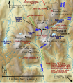
File:Cairngorm relief map for 1971 disaster.svg
Appearance

Size of this PNG preview of this SVG file: 526 × 599 pixels. Other resolutions: 211 × 240 pixels | 421 × 480 pixels | 674 × 768 pixels | 899 × 1,024 pixels | 1,798 × 2,048 pixels | 712 × 811 pixels.
Original file (SVG file, nominally 712 × 811 pixels, file size: 904 KB)
File history
Click on a date/time to view the file as it appeared at that time.
| Date/Time | Thumbnail | Dimensions | User | Comment | |
|---|---|---|---|---|---|
| current | 10:27, 12 April 2016 |  | 712 × 811 (904 KB) | Thincat | Jean's Hut had been moved by 1971 |
| 20:43, 11 April 2016 |  | 712 × 811 (901 KB) | Thincat | Correct the elevation of Pools of Dee | |
| 09:17, 9 April 2016 |  | 712 × 811 (916 KB) | Thincat | Mark Pools of Dee | |
| 09:06, 9 April 2016 |  | 712 × 811 (902 KB) | Thincat | Curran shelter on south shore of Lochan Buidhe | |
| 08:57, 14 March 2016 |  | 712 × 811 (889 KB) | Thincat | More accurate locations | |
| 14:10, 2 March 2016 |  | 712 × 811 (852 KB) | Thincat | Add Shelter Stone | |
| 13:30, 2 March 2016 |  | 712 × 811 (839 KB) | Thincat | Update bothy information | |
| 23:20, 21 February 2016 |  | 712 × 811 (768 KB) | Thincat | More accurate location for disaster | |
| 22:45, 21 February 2016 |  | 712 × 811 (768 KB) | Thincat | update warning about shelters | |
| 22:34, 21 February 2016 |  | 712 × 811 (768 KB) | Thincat | Added St Valery shelter |
File usage
The following page uses this file:
Global file usage
The following other wikis use this file:
- Usage on es.wikipedia.org
