
File:Caert van't Landt van d'Eendracht (detail showing Willems River).jpg
No higher resolution available.
Caert_van't_Landt_van_d'Eendracht_(detail_showing_Willems_River).jpg (712 × 532 pixels, file size: 254 KB, MIME type: image/jpeg)
| This is a file from the Wikimedia Commons. Information from its description page there is shown below. Commons is a freely licensed media file repository. You can help. |
.jpg)
Summary
| Description |
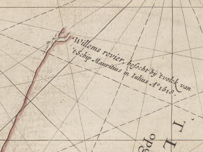
English: This is an image showing detail of the National Library of Australia's copy of Hessel Gerritsz' 1627 map of the north west coast of Australia entitled "Caert van't Landt van d'Eendracht".
This detail shows features labelled "Willems revier, besocht by 't volck van 't Schip Mauritius in Iulius A° 1618" ("Willem's River, visited by the crew of the ship Mauritius in July 1618"). |
| Date | |
| Source | Cropped from the full scan, available at Image:Caert van't Landt van d'Eendracht (NLA balanced).jpg |
| Author | Hessel Gerritsz, also written "Hessel Gerritszoon". |
| Other versions | For other versions, see Category:Caert van't Landt van d'Eendracht. |
.jpg)
Licensing
|
This work is in the public domain in its country of origin and other countries and areas where the copyright term is the author's life plus 100 years or fewer. | |
| This file has been identified as being free of known restrictions under copyright law, including all related and neighboring rights. | |
File history
Click on a date/time to view the file as it appeared at that time.
| Date/Time | Thumbnail | Dimensions | User | Comment | |
|---|---|---|---|---|---|
| current | 16:18, 29 January 2012 | | 712 × 532 (254 KB) | KHS-Boab | {{Information |description={{en|1=This is an image showing detail of the National Library of Australia's copy of Hessel Gerritsz' 1627 map of the north west coast of Australia entitled "Caert van't Landt van d'Eendracht". This detail shows features label |
File usage
The following 4 pages use this file:
Global file usage
The following other wikis use this file:
- Usage on es.wikipedia.org
- Usage on nl.wikipedia.org
.jpg)