File:Cadastre Vaulerent 1823.jpg
Appearance

Size of this preview: 690 × 600 pixels. Other resolutions: 276 × 240 pixels | 552 × 480 pixels | 980 × 852 pixels.
Original file (980 × 852 pixels, file size: 390 KB, MIME type: image/jpeg)
File history
Click on a date/time to view the file as it appeared at that time.
| Date/Time | Thumbnail | Dimensions | User | Comment | |
|---|---|---|---|---|---|
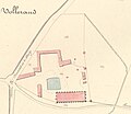
| current | 20:12, 2 May 2011 |  | 980 × 852 (390 KB) | Mel22 | {{Information |Description ={{en|1=Plan of the Vaulerent Barn. Cadastral map of Villeron, former Seine-et-Oise, now Val-d'Oise, France}} {{fr|1=Plan de la ferme de Vaulerent. Cadastre napoléonien de la commune de Villeron, anciennement Seine-et-Oise, |
File usage
The following page uses this file:
Global file usage
The following other wikis use this file:
- Usage on fr.wikipedia.org
