Jump to content

File:COVID-19 Outbreak America Map.svg

Page contents not supported in other languages.
This is a file from the Wikimedia Commons
From Wikipedia, the free encyclopedia

Original file (SVG file, nominally 1,064 × 1,201 pixels, file size: 529 KB)

This image should always reflect the most recent version. Feel free to update it when needed.
This file may be updated to reflect new information.
If you wish to use a specific version of the file without it being overwritten, please upload the required version as a separate file.

Summary

Description
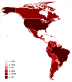
English (en): Map of the COVID-19 outbreak as of 13 April 2020 in America. Be aware that since this is a rapidly evolving situation, new cases may not be immediately represented visually. Refer to the primary article Pandemia de enfermedad por coronavirus de 2020 en América or the World Health Organization's situation reports for most recent reported case information.
 
1,000,000+ Confirmed cases
 
100,000–999,999 Confirmed cases
 
10,000–99999 Confirmed cases
 
1000–9999 Confirmed cases
 
100–999 Confirmed cases
 
1-99 Confirmed cases
Date
Source
 
This SVG map includes elements that have been taken or adapted from this map:
Latinameriko.svg.
Data derived from Coronavirus COVID-19 Global Cases by the Center for Systems Science and Engineering (CSSE) at Johns Hopkins University (JHU)
Author Basque mapping
SVG development
InfoField
 
The source code of this SVG is invalid due to 5 errors.
 
This W3C-invalid world map was created with Inkscape.
 
 This world map uses embedded text that can be easily translated using a text editor.

Licensing

I, the copyright holder of this work, hereby publish it under the following license:
w:en:Creative Commons
attribution share alike
This file is licensed under the Creative Commons Attribution-Share Alike 4.0 International license.
You are free:
  • to share – to copy, distribute and transmit the work
  • to remix – to adapt the work
Under the following conditions:
  • attribution – You must give appropriate credit, provide a link to the license, and indicate if changes were made. You may do so in any reasonable manner, but not in any way that suggests the licensor endorses you or your use.
  • share alike – If you remix, transform, or build upon the material, you must distribute your contributions under the same or compatible license as the original.
Any autoconfirmed user can overwrite this file from the same source. Please ensure that overwrites comply with the guideline.

Captions

Map of COVID-19 infected countries and territories in America

Items portrayed in this file

depicts

19 March 2020

image/svg+xml

8079cf8103d8cc3b858c95688dc06a53c2308fa0

542,116 byte

1,201 pixel

1,064 pixel

File history

Click on a date/time to view the file as it appeared at that time.

Date/TimeThumbnailDimensionsUserComment
current18:13, 1 August 2020Thumbnail for version as of 18:13, 1 August 20201,064 × 1,201 (529 KB)Patrick N. Pozo PuertaUpdate
18:26, 13 April 2020Thumbnail for version as of 18:26, 13 April 20201,064 × 1,201 (523 KB)Basque mappingUpdate
11:56, 28 March 2020Thumbnail for version as of 11:56, 28 March 20201,064 × 1,201 (523 KB)Basque mappingUpdate
12:00, 22 March 2020Thumbnail for version as of 12:00, 22 March 20201,064 × 1,201 (523 KB)Basque mappingUpdate
12:04, 21 March 2020Thumbnail for version as of 12:04, 21 March 20201,064 × 1,201 (523 KB)Basque mappingUpdate
10:49, 20 March 2020Thumbnail for version as of 10:49, 20 March 20201,064 × 1,201 (523 KB)Basque mappingUpdate
16:43, 19 March 2020Thumbnail for version as of 16:43, 19 March 20201,064 × 1,201 (523 KB)Basque mappingUploaded own work with UploadWizard

The following page uses this file:

Global file usage

The following other wikis use this file:

Metadata