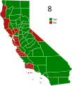
File:CA2008Prop8.svg
Appearance

Size of this PNG preview of this SVG file: 508 × 600 pixels. Other resolutions: 203 × 240 pixels | 407 × 480 pixels | 651 × 768 pixels | 867 × 1,024 pixels | 1,735 × 2,048 pixels | 621 × 733 pixels.
Original file (SVG file, nominally 621 × 733 pixels, file size: 261 KB)
File history
Click on a date/time to view the file as it appeared at that time.
| Date/Time | Thumbnail | Dimensions | User | Comment | |
|---|---|---|---|---|---|
| current | 00:54, 27 June 2013 |  | 621 × 733 (261 KB) | Haha169 | fix map |
| 01:44, 9 November 2012 |  | 621 × 733 (261 KB) | Haha169 | haha ... San Francisco did not vote for Prop 8 | |
| 12:28, 12 March 2012 |  | 621 × 733 (256 KB) | Erina | Changed colours to be more readable for people with colourblindness. | |
| 02:09, 20 April 2011 |  | 621 × 733 (253 KB) | Haha169 | Reverted to version as of 20:17, 9 June 2010 - crosshatch not working, (ex. marin county not cross hatched and some counties have an odd yellow border), plus it looks ugly. Colors need changing, not patterns. | |
| 21:43, 5 March 2011 |  | 621 × 733 (259 KB) | Rfc1394 | Readjust "no" value for two counties that were not showing cross-hatch | |
| 21:37, 5 March 2011 |  | 621 × 733 (259 KB) | Rfc1394 | Make cross-hatch on "no" counties easier to see | |
| 21:27, 5 March 2011 |  | 621 × 733 (259 KB) | Rfc1394 | Make the maroon Yes counties into maroon/white crosshatch to make it easier to visualize for the color blind. | |
| 20:17, 9 June 2010 |  | 621 × 733 (253 KB) | Kurykh | fix Napa | |
| 20:15, 9 June 2010 |  | 621 × 733 (253 KB) | Kurykh | fix San Joaquin boundaries | |
| 00:01, 22 May 2009 |  | 621 × 733 (349 KB) | Haha169 | {{Information |Description={{en|1=Election maps of California's 2008 elections 8)}} |Source=Own work by uploader |Author=Haha169 |Date= |Permission= |other_versions= }} <!--{{ImageUpload|full}}--> [[Category:Electoral maps of California] |
File usage
The following page uses this file:
Global file usage
The following other wikis use this file:
- Usage on en.wikinews.org


