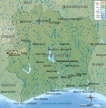
File:Côte d'Ivoire topographic map-fr.svg
Appearance

Size of this PNG preview of this SVG file: 586 × 599 pixels. Other resolutions: 235 × 240 pixels | 469 × 480 pixels | 751 × 768 pixels | 1,001 × 1,024 pixels | 2,003 × 2,048 pixels | 843 × 862 pixels.
Original file (SVG file, nominally 843 × 862 pixels, file size: 1.67 MB)
File history
Click on a date/time to view the file as it appeared at that time.
| Date/Time | Thumbnail | Dimensions | User | Comment | |
|---|---|---|---|---|---|
| current | 15:20, 20 February 2009 |  | 843 × 862 (1.67 MB) | Bourrichon | . |
| 14:44, 20 February 2009 |  | 843 × 862 (1.67 MB) | Bourrichon | + lacs/lagunes | |
| 14:23, 20 February 2009 |  | 843 × 862 (1.62 MB) | Bourrichon | {{Information |Description={{fr|Carte physique de la Côte d'Ivoire. Note : le fond de carte (relief + rivières) est un bitmap (SRTM30 v.2/domaine publique) embarqué dans le svg à l'aide d'Inkscape.}} {{en|Map of [[:en:Côte d'Iv |
File usage
The following page uses this file:
Global file usage
The following other wikis use this file:
- Usage on ca.wikipedia.org
- Usage on ckb.wikipedia.org
- Usage on fa.wikipedia.org
- Usage on fr.wikipedia.org
- Usage on hr.wiktionary.org
- Usage on id.wikipedia.org
- Usage on mdf.wikipedia.org
- Usage on mzn.wikipedia.org
- Usage on nl.wikipedia.org
- Usage on uk.wikipedia.org
- Usage on www.wikidata.org


