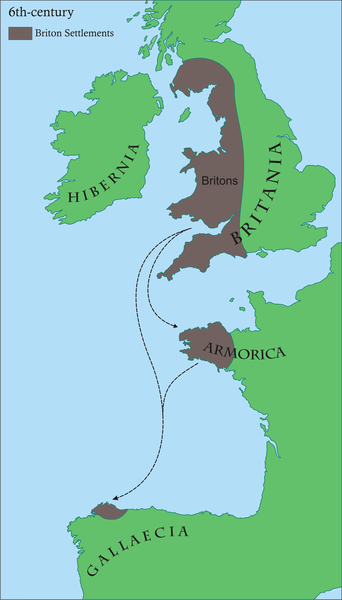
File:Britonia6hcentury.png
Appearance

Size of this preview: 342 × 600 pixels. Other resolutions: 137 × 240 pixels | 274 × 480 pixels | 438 × 768 pixels | 584 × 1,024 pixels | 1,670 × 2,928 pixels.
Original file (1,670 × 2,928 pixels, file size: 542 KB, MIME type: image/png)
File history
Click on a date/time to view the file as it appeared at that time.
| Date/Time | Thumbnail | Dimensions | User | Comment | |
|---|---|---|---|---|---|
| current | 08:45, 17 June 2008 |  | 1,670 × 2,928 (542 KB) | Le Galicien | {{Information |Description={{gl|1=Mapa dos asentamentos britónicos no occidente europeo arredor do século VI da nosa era. Os territorios aparecen en marrón, mentres o verde indica a situación xeográfica.}} |Source=Own work by uploader |Author=Rubén |
File usage
The following 15 pages use this file:
- 510
- Armorica
- Bretons
- Brittany
- Celtic Britons
- History of Brittany
- History of Galicia
- Kingdom of the Suebi
- Romano-British culture
- Timeline of Cornish history
- User:Anuragngoel/Romano-British culture
- User:Ibonarzua/sandbox/Wikipedia improvement2
- User talk:Chzz/Archive 11
- User talk:SPQRobin
- Wikipedia:Reference desk/Archives/Humanities/2011 April 29
Global file usage
The following other wikis use this file:
- Usage on af.wikipedia.org
- Usage on als.wikipedia.org
- Usage on an.wikipedia.org
- Usage on arz.wikipedia.org
- Usage on ast.wikipedia.org
- Usage on azb.wikipedia.org
- Usage on be.wikipedia.org
- Usage on bg.wikipedia.org
- Usage on bn.wikipedia.org
- Usage on br.wikipedia.org
- Usage on ca.wikipedia.org
- Usage on cs.wikipedia.org
- Usage on cy.wikipedia.org
- Usage on el.wikipedia.org
- Usage on es.wikipedia.org
- Usage on eu.wikipedia.org
- Usage on fa.wikipedia.org
- Usage on fi.wikipedia.org
- Usage on fi.wikibooks.org
- Usage on fr.wikipedia.org
View more global usage of this file.


