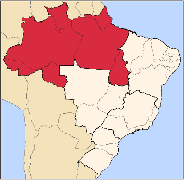
File:Brazil Region Norte.svg
Appearance

Size of this PNG preview of this SVG file: 613 × 600 pixels. Other resolutions: 245 × 240 pixels | 490 × 480 pixels | 785 × 768 pixels | 1,046 × 1,024 pixels | 2,093 × 2,048 pixels | 702 × 687 pixels.
Original file (SVG file, nominally 702 × 687 pixels, file size: 442 KB)
File history
Click on a date/time to view the file as it appeared at that time.
| Date/Time | Thumbnail | Dimensions | User | Comment | |
|---|---|---|---|---|---|
| current | 23:17, 11 September 2022 |  | 702 × 687 (442 KB) | Heitordp | Updated border between Acre and Amazonas |
| 20:28, 21 April 2006 |  | 702 × 687 (448 KB) | Raphael.lorenzeto | {{Information| |Description=Map locator of Brazil's Norte region |Source=own work |Date=April, 21 2006 |Author=Raphael Lorenzeto de Abreu |Permission={{self2|GFDL|cc-by-2.5}} |other_versions= }} Category:Maps of Brazil |
File usage
The following 2 pages use this file:
Global file usage
The following other wikis use this file:
- Usage on az.wikipedia.org
- Usage on bg.wikipedia.org
- Usage on cs.wikipedia.org
- Usage on da.wikipedia.org
- Usage on de.wikipedia.org
- Usage on el.wikivoyage.org
- Usage on eo.wikipedia.org
- Usage on es.wikipedia.org
- Usage on et.wikipedia.org
- Usage on fa.wikipedia.org
- Usage on fi.wikipedia.org
- Usage on frr.wikipedia.org
- Usage on io.wikipedia.org
- Usage on ka.wikipedia.org
- Usage on ko.wikipedia.org
- Usage on lt.wikipedia.org
- Usage on mk.wikipedia.org
- Usage on nl.wikipedia.org
- Usage on oc.wikipedia.org
- Usage on pt.wikipedia.org
- Amapá
- Amazonas
- Rondônia
- Roraima
- Tocantins
- Acre
- Fortaleza Esporte Clube
- Rio Branco
- Boa Vista (Roraima)
- Belém (Pará)
- Paysandu Sport Club
- Categoria:Acre
- Macapá
- Categoria:Amapá
- Categoria:Rondônia
- Santa Isabel do Rio Negro
- São Gabriel da Cachoeira
- Clube Náutico Capibaribe
- Categoria:Pará
- Categoria:Amazonas
- Região Norte do Brasil
- Pico da Neblina
View more global usage of this file.


