
File:Braunschweig Luftaufnahme Oestliches Ringgebiet (2011).JPG

Size of this preview: 800 × 600 pixels. Other resolutions: 320 × 240 pixels | 640 × 480 pixels | 1,024 × 768 pixels | 1,280 × 960 pixels | 2,560 × 1,920 pixels.
Original file (2,560 × 1,920 pixels, file size: 1.56 MB, MIME type: image/jpeg)
| This is a file from the Wikimedia Commons. Information from its description page there is shown below. Commons is a freely licensed media file repository. You can help. |
.JPG)
Summary
| Description |
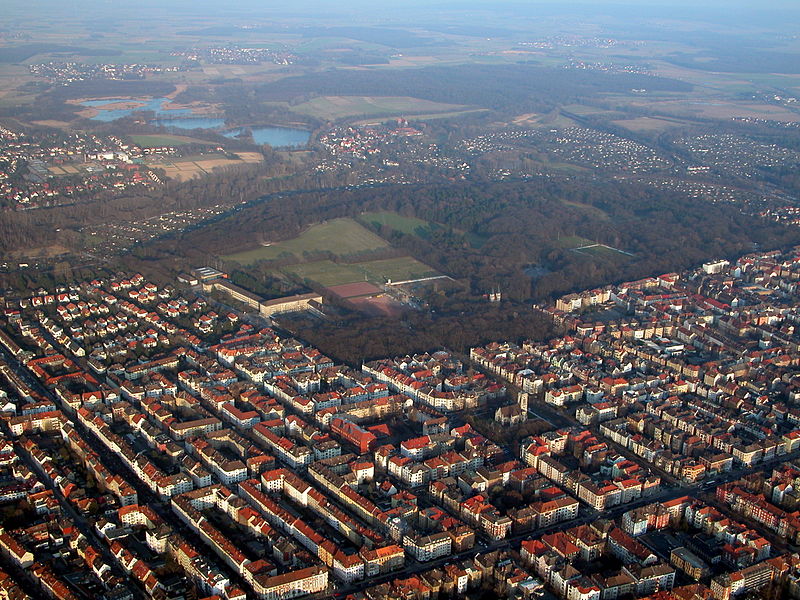
Deutsch: Braunschweig: Blick über das östliche Ringgebiet. Im Zentrum der Prinzenpark mit dem Nußberg. In Hintergrund Riddagshausen mit Kreuzteich, Mittelteich und Schapenbruchteich (Blickrichtung Südosten). |
| Date | |
| Source | Own work (Benutzer:Brunswyk) |
| Author | Brunswyk at de.wikipedia |
| Permission (Reusing this file) |
CC-BY-SA-3.0-DE. |
Licensing
This file is licensed under the Creative Commons Attribution-Share Alike 3.0 Germany license.
- You are free:
- to share – to copy, distribute and transmit the work
- to remix – to adapt the work
- Under the following conditions:
- attribution – You must give appropriate credit, provide a link to the license, and indicate if changes were made. You may do so in any reasonable manner, but not in any way that suggests the licensor endorses you or your use.
- share alike – If you remix, transform, or build upon the material, you must distribute your contributions under the same or compatible license as the original.

Original upload log
The original description page was here. All following user names refer to de.wikipedia.
- 2011-07-30 12:46 Brunswyk 2560×1920× (1630933 bytes) {{Information |Beschreibung =[[Braunschweig]]: Blick über das [[Östliches Ringgebiet|östliche Ringgebiet]]. Im Zentrum der [[Prinz-Albrecht-Park|Prinzenpark]] mit dem [[Nußberg (Braunschweig)|Nußberg]]. In Hintergrund [[Kloster Riddagshausen|Riddagsh
File history
Click on a date/time to view the file as it appeared at that time.
| Date/Time | Thumbnail | Dimensions | User | Comment | |
|---|---|---|---|---|---|
| current | 01:13, 3 September 2011 | | 2,560 × 1,920 (1.56 MB) | File Upload Bot (Magnus Manske) | {{BotMoveToCommons|de.wikipedia|year={{subst:CURRENTYEAR}}|month={{subst:CURRENTMONTHNAME}}|day={{subst:CURRENTDAY}}}} {{Information |Description={{de|de:Braunschweig: Blick über das östliche Ringgebiet. Im Zentrum d |
File usage
The following 2 pages use this file:
Global file usage
The following other wikis use this file:
- Usage on ast.wikipedia.org
- Usage on ceb.wikipedia.org
- Usage on de.wikipedia.org
- Braunschweig
- Östliches Ringgebiet
- Viewegsgarten-Bebelhof
- Innenstadt (Braunschweig)
- Portal:Braunschweig/Archiv Artikel des Monats
- Bebelhof (Braunschweig)
- Vorlage Diskussion:Navigationsleiste Stadtteile in Braunschweig
- Westliches Ringgebiet
- Prinz-Albrecht-Park
- Vorlage:Navigationsleiste Stadtquartiere in Braunschweig
- Benutzer:Brunswyk/Meine Fotos
- Nördliches Ringgebiet
- Jasperallee
- Siegfriedviertel
- Benutzer:Aeroid/List DE NI-BS
- Usage on de.wikivoyage.org
- Usage on es.wikipedia.org
- Usage on et.wikipedia.org
- Usage on fa.wikipedia.org
- Usage on sq.wikipedia.org
- Usage on ur.wikipedia.org
- Usage on www.wikidata.org
.JPG)