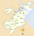
File:Boston ONS Neighborhoods.svg
Appearance

Size of this PNG preview of this SVG file: 554 × 599 pixels. Other resolutions: 222 × 240 pixels | 444 × 480 pixels | 710 × 768 pixels | 947 × 1,024 pixels | 1,893 × 2,048 pixels | 709 × 767 pixels.
Original file (SVG file, nominally 709 × 767 pixels, file size: 946 KB)
File history
Click on a date/time to view the file as it appeared at that time.
| Date/Time | Thumbnail | Dimensions | User | Comment | |
|---|---|---|---|---|---|
| current | 18:19, 18 November 2021 |  | 709 × 767 (946 KB) | Goran tek-en | ppi to 96, optimized, color deficiency OK |
| 11:58, 9 February 2014 |  | 709 × 767 (1.44 MB) | Goran tek-en | User created page with UploadWizard |
File usage
The following 3 pages use this file:
Global file usage
The following other wikis use this file:
- Usage on azb.wikipedia.org
- Usage on ceb.wikipedia.org
- Usage on es.wikipedia.org
- Usage on fr.wikipedia.org
- Charlestown (Boston)
- Dorchester (Boston)
- Beacon Hill (Boston)
- Roxbury (Boston)
- North End (Boston)
- Liste des quartiers de Boston
- Allston (Boston)
- Back Bay
- Chinatown (Boston)
- Roslindale
- Jamaica Plain
- Bay Village (Boston)
- West Roxbury
- Brighton (Boston)
- East Boston
- Fenway Kenmore
- Hyde Park (Boston)
- Mattapan
- Mission Hill (Boston)
- South End (Boston)
- West End (Boston)
- Downtown Boston
- Usage on pt.wikipedia.org
- Usage on www.wikidata.org

