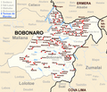
File:Bobonaro posto administrativo.png
Appearance

Size of this preview: 700 × 600 pixels. Other resolutions: 280 × 240 pixels | 560 × 480 pixels | 879 × 753 pixels.
Original file (879 × 753 pixels, file size: 310 KB, MIME type: image/png)
File history
Click on a date/time to view the file as it appeared at that time.
| Date/Time | Thumbnail | Dimensions | User | Comment | |
|---|---|---|---|---|---|
| current | 22:37, 15 July 2015 |  | 879 × 753 (310 KB) | J. Patrick Fischer | +Hauba, minor corrections |
| 08:33, 17 August 2014 |  | 879 × 753 (307 KB) | J. Patrick Fischer | Termas do Marobo added. Spelling of some villages corrected. | |
| 18:34, 10 April 2010 |  | 879 × 753 (288 KB) | J. Patrick Fischer | Überarbeitet | |
| 16:05, 13 March 2010 |  | 879 × 753 (282 KB) | J. Patrick Fischer | {{Information |Description={{en|1=The subdistrict of Bobonaro, district Bobonaro, East Timor}} {{de|1=Der Subdistrikt Bobonaro, Distrikt Bobonaro, Osttimor}} |Source=Eigenes Werk unter Verwendung von [[:File:Administrative map of the Bobonaro district of |
File usage
The following page uses this file:
Global file usage
The following other wikis use this file:
- Usage on de.wikipedia.org
- Usage on fi.wikipedia.org
- Usage on id.wikipedia.org
- Usage on pt.wikipedia.org
- Usage on tet.wikipedia.org
- Usage on ur.wikipedia.org
