Jump to content

File:Bishop tuff.jpg

Page contents not supported in other languages.
This is a file from the Wikimedia Commons
From Wikipedia, the free encyclopedia

Bishop_tuff.jpg (800 × 500 pixels, file size: 139 KB, MIME type: image/jpeg)

Summary

Description
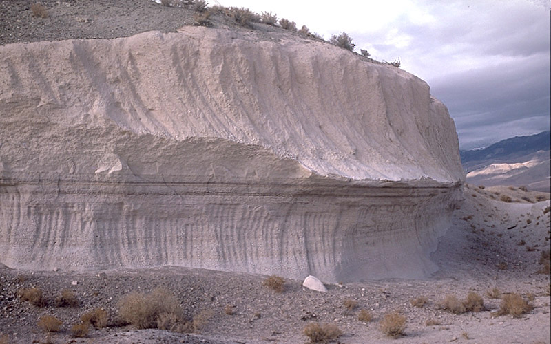
English: Photo showing two layers of Bishop tuff, eastern California, United States.
This outcrop is exposed in a rock quarry in Chalfant Valley about 25 km southeast of Long Valley Caldera. The two main units of the Bishop Tuff deposit are visible here: (1) the lower 5 m of the section consists of the pumice that fell to the ground (airfall pumice) downwind from the eruption; and (2) the upper 5-6 m of the section consists of the basal part of the pyroclastic flows that swept at hurricane speed away from the eruption. The thin dark "layers" just below the contact between the units are stains from an ancient groundwater table (manganese oxide stains).
Date Taken on 29 October 1987
Source Archived source link
Author Roy A. Bailey

Licensing

Public domain
This image is in the public domain in the United States because it only contains materials that originally came from the United States Geological Survey, an agency of the United States Department of the Interior. For more information, see the official USGS copyright policy.

Bahasa Indonesia  català  čeština  Deutsch  eesti  English  español  français  galego  italiano  Nederlands  português  polski  sicilianu  suomi  Tiếng Việt  Türkçe  български  македонски  русский  മലയാളം  한국어  日本語  中文  中文(简体)  中文(繁體)  العربية  فارسی  +/−

Captions

Layers of Bishop tuff

Items portrayed in this file

depicts

29 October 1987

image/jpeg

defa794aa32309b7503c5190481b3a16acab6fc3

142,049 byte

500 pixel

800 pixel

File history

Click on a date/time to view the file as it appeared at that time.

Date/TimeThumbnailDimensionsUserComment
current04:58, 15 April 2007Thumbnail for version as of 04:58, 15 April 2007800 × 500 (139 KB)Hike395{{Information |Description = Photo showing two layers of Bishop tuff, eastern California, United States |Source = http://lvo.wr.usgs.gov/gallery/30714277-048_caption.html |Date = 1987-10-29 |Author = Roy A. Bailey |Permission = }} USGS

The following 3 pages use this file:

Global file usage

The following other wikis use this file:

Metadata