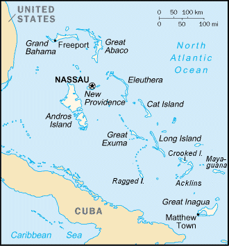
File:Bf-map names SE.png
Appearance
Bf-map_names_SE.png (330 × 355 pixels, file size: 20 KB, MIME type: image/png)
| This image appeared on Wikipedia's Main Page in the Did you know? column on 19 September 2004 (see archives). |
File history
Click on a date/time to view the file as it appeared at that time.
| Date/Time | Thumbnail | Dimensions | User | Comment | |
|---|---|---|---|---|---|
| current | 23:15, 10 May 2008 |  | 330 × 355 (20 KB) | File Upload Bot (Magnus Manske) | {{BotMoveToCommons|en.wikipedia}} {{Information |Description={{en|From [[:en::Image:Bf-map.gif]] with more islands identified in the SE sector.}} |Source=Transferred from [http://en.wikipedia.org en.wikipedia]; Transfer was stated to be made by [[User:J� |
File usage
The following 3 pages use this file:
Global file usage
The following other wikis use this file:
- Usage on be.wikipedia.org
- Usage on ca.wikipedia.org
- Usage on el.wikipedia.org
- Usage on eo.wikipedia.org
- Usage on fa.wikipedia.org
- Usage on hy.wikipedia.org
- Usage on id.wikipedia.org
- Usage on ru.wikipedia.org
- Usage on simple.wikipedia.org
- Usage on sv.wikipedia.org
- Usage on vi.wikipedia.org


