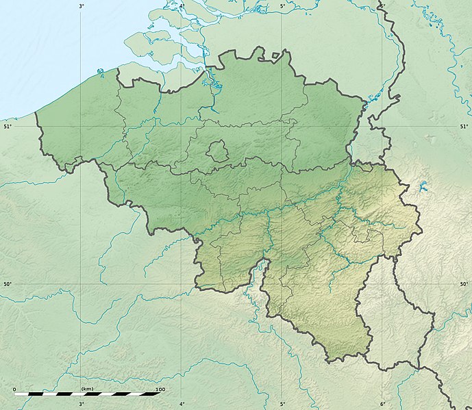
File:Belgium relief location map.jpg
Appearance

Size of this preview: 689 × 599 pixels. Other resolutions: 276 × 240 pixels | 552 × 480 pixels | 883 × 768 pixels | 1,136 × 988 pixels.
Original file (1,136 × 988 pixels, file size: 255 KB, MIME type: image/jpeg)
File history
Click on a date/time to view the file as it appeared at that time.
| Date/Time | Thumbnail | Dimensions | User | Comment | |
|---|---|---|---|---|---|
| current | 23:27, 23 September 2010 |  | 1,136 × 988 (255 KB) | Sting | == {{int:filedesc}} == {{Location|50|30|00|N|04|33|00|E|scale:1000000}} <br/> {{Information |Description= {{de|Relief Positionskarte von Belgien}} {{en|Physical location map of Belgium, for geo-location purposes.}} {{fr|Car |
File usage
More than 100 pages use this file. The following list shows the first 100 pages that use this file only. A full list is available.
- Aa of Weerijs
- Barrier Treaty
- Battle of Amblève
- Battle of Cassel (1677)
- Battle of Courtrai (1814)
- Battle of Furnes
- Battle of Kallo
- Battle of Landen
- Battle of Lauffeld
- Battle of Les Avins
- Battle of Oosterweel
- Battle of Ramillies
- Battle of Rocoux
- Battle of Saint-Denis (1678)
- Battle of Seneffe
- Battle of Steppes
- Battle of the Golden Spurs
- Beersel Hills Observatory
- Beguinage
- Belfry of Bruges
- Belfry of Ghent
- Belfry of Kortrijk
- Belfry of Mons
- Belfry of Namur
- Belfry of Thuin
- Belfry of Tournai
- Belgian Open (golf)
- Belgium
- Blandijnberg
- Boat Lifts on the Canal du Centre
- Brussels
- Château de La Fougeraie
- Cinematek
- Croix Scaille
- Donkmeer
- Eau d'Heure lakes
- Eisenmann Synagogue
- Fall of Ghent
- Fortified position of Liège
- Franco-Spanish War (1635–1659)
- Gileppe Dam
- Goyet Caves
- Grand Large
- Great Beguinage, Leuven
- Hoge Kempen National Park
- Hollandse Synagoge
- Ieper Group
- Jean Wauquelin
- KPMG Trophy
- La Cornette
- Lake Bütgenbach
- Lake Eupen
- Lake Genval
- Lake Gileppe
- Lake Neufchâteau
- Lake Nisramont
- Lake Robertville
- Lake Ry de Rome
- Lake Virelles
- Lake Warfaaz
- Legends in Golf
- Lys (river)
- Maison Guiette
- Malmedy massacre
- Menno van Coehoorn
- Mont Noir
- Motorized Brigade (Belgium)
- Museum for Old Techniques
- Naulette
- Neolithic flint mines of Spiennes
- Old Town Hall, Lo
- Peerdsbos
- Perrier European Pro-Am
- Plantin–Moretus Museum
- Polygon Wood, Zonnebeke
- Redu Station
- Royal Observatory of Belgium
- Saint Leonard's Church, Zoutleeuw
- Scheldt
- Scladina
- Scots Brigade
- Second Allied Tactical Air Force
- Siege of Cambrai (1677)
- Siege of Maastricht (1673)
- Siege of Namur (1695)
- Siege of Tournai (1340)
- Siege of Valenciennes (1676–1677)
- Signal de Botrange
- Special Operations Regiment (Belgium)
- Spy Cave
- Steling
- Ten Wijngaerde (Begijnhof Brugge)
- Trou de l'Abîme
- Vaalserberg
- War of Devolution
- War of the Spanish Succession
- Weißer Stein (Eifel)
- User:ChrisVleugels/sandbox
- User:Cinoreros/Peerdsbos
- User:OldSpot61/Sandbox
View more links to this file.
Global file usage
The following other wikis use this file:
- Usage on als.wikipedia.org
- Usage on ar.wikipedia.org
- Usage on ast.wikipedia.org
- Usage on as.wikipedia.org
- Usage on av.wikipedia.org
- Usage on az.wikipedia.org
- Usage on ba.wikipedia.org
- Usage on be.wikipedia.org
- Usage on bg.wikipedia.org
- Usage on bn.wikipedia.org
- Usage on bs.wikipedia.org
- Usage on ca.wikipedia.org
- Usage on ceb.wikipedia.org
- Usage on ce.wikipedia.org
- Usage on ch.wikipedia.org
- Usage on ckb.wikipedia.org
- Usage on cs.wikipedia.org
View more global usage of this file.


