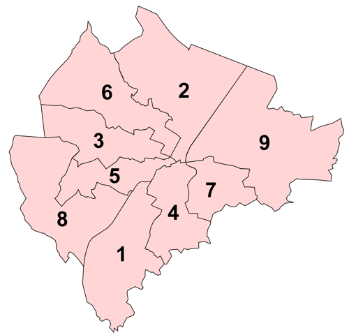
File:Belfast DEAs labelled.png
Appearance
Belfast_DEAs_labelled.png (500 × 480 pixels, file size: 56 KB, MIME type: image/png)
File history
Click on a date/time to view the file as it appeared at that time.
| Date/Time | Thumbnail | Dimensions | User | Comment | |
|---|---|---|---|---|---|
| current | 00:07, 12 June 2011 |  | 500 × 480 (56 KB) | Rathgarrr | Smaller version |
| 00:02, 12 June 2011 |  | 5,033 × 4,840 (664 KB) | Rathgarrr |
File usage
The following page uses this file:
Global file usage
The following other wikis use this file:
- Usage on eu.wikipedia.org
- Belfast
- Falls Road
- Shankill Road
- Gaeltacht Quarter (Belfast)
- Lankide:Euskaldunaa
- Great Victoria Street
- Andersonstown
- Bóthar Seoighe
- Dundonald
- Braniel
- Cregagh
- Ardoyne
- Txantiloi:Belfast
- Wikiproiektu:Irlanda, Gales eta Eskoziako udalerriak
- Clarawood
- Cathedral Quarter (Belfast)
- Library Quarter (Belfast)
- Linen Quarter (Belfast)
- Market Quarter (Belfast)
- Queen's Quarter (Belfast)
- Smithfield and Union Quarter (Belfast)
- Titanic Quarter
- Belfasteko portua
- Belfasteko Erdialdea
- Belfasteko hirigunea
- New Lodge (Belfast)
- Newtownbreda
- Poleglass
- Taughmonagh
- Strandtown
- Balmoral (Belfast)
- Finaghy
- Castle (Belfast)
- Ballymacarrett
- Short Strand
- Court (Belfast)
- Laganbank
- Lower Falls (Belfast)
- Oldpark (Belfast)
- Pottinger (Belfast)
- Upper Falls (Belfast)
- Ormiston (Belfast)
- Victoria (Belfast)
- Stranmillis
- Cherryvalley
- Sandy Row
- Lisnasharragh (Belfast)
- Black Mountain (hauteskunde-barrutia)
- Botanic (Belfast)
- Collin (Belfast)
View more global usage of this file.

