Jump to content

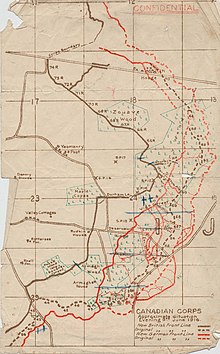
File:Battle of Mount Sorrel - Battle Map - June 6 (restored1).jpg

Page contents not supported in other languages.
This is a file from the Wikimedia Commons
From Wikipedia, the free encyclopedia

Original file (1,741 × 2,800 pixels, file size: 1.94 MB, MIME type: image/jpeg)

Description
English: This map illustrates the British/Canadian positions (in brown) and the German lines (in red) on 4 June 1916, during the Battle of Mount Sorrel. The Canadians have been driven from several strong points, including Hooge north), Mount Sorrel itself (south), and most of Observatory Ridge (centre).
Date
Source George Metcalf Archival Collection, Canadian War Museum: 19870027-018
[1]
Author n.d.
Permission
(Reusing this file)
Public domain
This Canadian work is in the public domain in Canada because its copyright has expired due to one of the following:
1. it was subject to Crown copyright and was first published more than 50 years ago, or

it was not subject to Crown copyright, and

2. it is a photograph that was created prior to January 1, 1949, or
3. the creator died prior to January 1, 1972.

You must also include a United States public domain tag to indicate why this work is in the public domain in the United States.

العربية  বাংলা  čeština  Deutsch  English  español  suomi  français  italiano  日本語  한국어  македонски  മലയാളം  Nederlands  português  português do Brasil  sicilianu  slovenščina  简体中文  繁體中文  +/−

Other versions
Unrestored version
This is a retouched picture, which means that it has been digitally altered from its original version. Modifications: Tears, holes and major folds & creases repaired or decreased in intensity..

Camera location50° 50′ 28.83″ N, 2° 56′ 54.44″ E Kartographer map based on OpenStreetMap.View this and other nearby images on: OpenStreetMapinfo

Captions

Add a one-line explanation of what this file represents

Items portrayed in this file

depicts

June 1916Gregorian

50°50'28.831"N, 2°56'54.442"E

image/jpeg

07b00e15af1c62bd71454dfa0e49d7cb2aba54de

2,036,138 byte

2,800 pixel

1,741 pixel

File history

Click on a date/time to view the file as it appeared at that time.

Date/TimeThumbnailDimensionsUserComment
current21:12, 19 December 2009Thumbnail for version as of 21:12, 19 December 20091,741 × 2,800 (1.94 MB)Labattblueboy{{Information |Description={{en|1=This map illustrates the British/Canadian positions (in brown) and the German lines (in red) on 4 June 1916, during the Battle of Mount Sorrel. The Canadians have been driven from several strong points, including Hooge no

Global file usage

The following other wikis use this file:

Metadata