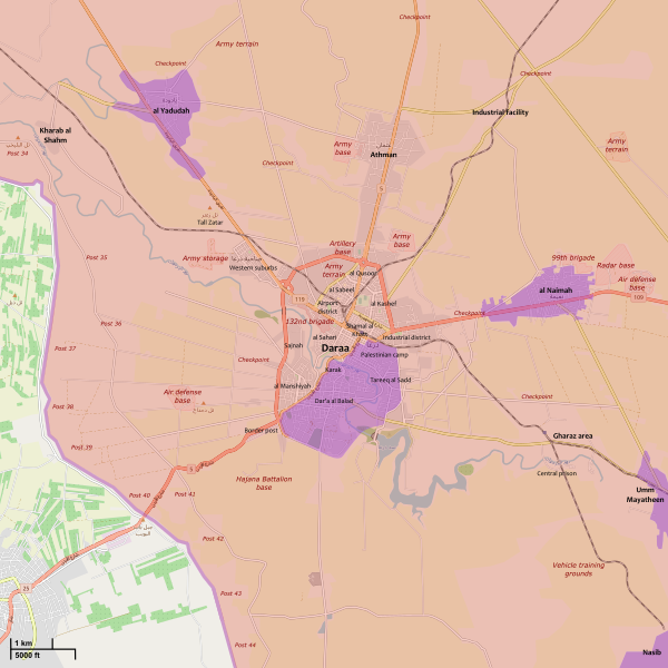
File:Battle of Daraa City.svg
Appearance

Size of this PNG preview of this SVG file: 600 × 600 pixels. Other resolutions: 240 × 240 pixels | 480 × 480 pixels | 768 × 768 pixels | 1,024 × 1,024 pixels | 2,048 × 2,048 pixels | 1,500 × 1,500 pixels.
Original file (SVG file, nominally 1,500 × 1,500 pixels, file size: 2.8 MB)
File history
Click on a date/time to view the file as it appeared at that time.
| Date/Time | Thumbnail | Dimensions | User | Comment | |
|---|---|---|---|---|---|
| current | 17:26, 19 September 2021 |  | 1,500 × 1,500 (2.8 MB) | Rr016 | Update. Syrian Army forced new agreement for Daraa Al-Balad (Sept. 5), Al-Yadudah (Sept. 13), Muzayrib (Sept. 16), and Tafas (Sept. 18)) |
| 13:13, 1 August 2021 |  | 1,500 × 1,500 (2.81 MB) | Rr016 | Overhauled map, made corrections | |
| 18:17, 12 July 2018 |  | 711 × 628 (564 KB) | Rr016 | Rebel forces in Daraa agree to reconcile; hostilities have ceased and the city is back under full SAA control... | |
| 19:59, 9 July 2018 |  | 711 × 628 (567 KB) | Rr016 | Big update: Daraa encircled | |
| 16:48, 6 July 2018 |  | 711 × 628 (567 KB) | Rr016 | Updates | |
| 20:22, 30 June 2018 |  | 711 × 628 (575 KB) | Rr016 | Let the map updates begin... | |
| 00:30, 21 April 2017 |  | 711 × 628 (580 KB) | MrPenguin20 | Wider surrounds of Daraa bit different atm (although I think the western/eastern frontlines are largely inactive) - e.g. see http://syria.liveuamap.com/. Updates on further advances in Daraa al-Manshiyah District by opposition groups - https://pbs.twim... | |
| 04:09, 3 March 2017 |  | 711 × 628 (597 KB) | Kami888 | based on https://pbs.twimg.com/media/C53GRnwWQAEX94B.jpg together with previously cited sources | |
| 14:07, 16 February 2017 |  | 711 × 628 (578 KB) | Kami888 | rebel offensive per multiple sources https://pbs.twimg.com/media/C4yN6ScWYAEtoBz.jpg https://pbs.twimg.com/media/C4x68O3XAAE6L2F.jpg https://pbs.twimg.com/media/C4o9mFTXAAAzavC.jpg https://archicivilians.files.wordpress.com/2017/02/daraa-feb14.jpg | |
| 14:49, 12 February 2016 |  | 711 × 628 (571 KB) | MrPenguin20 | Updates. |
File usage
The following 2 pages use this file:
Global file usage
The following other wikis use this file:
- Usage on ar.wikipedia.org
- Usage on fo.wikipedia.org
- Usage on id.wikipedia.org
- Usage on ku.wikipedia.org
- Usage on pa.wikipedia.org
- Usage on pl.wikipedia.org
- Usage on tr.wikipedia.org
- Usage on www.wikidata.org
- Usage on zh.wikipedia.org


