Jump to content

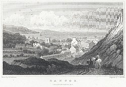
File:Bangor Caernarvonshire.jpeg

Page contents not supported in other languages.
This is a file from the Wikimedia Commons
From Wikipedia, the free encyclopedia

Original file (900 × 623 pixels, file size: 343 KB, MIME type: image/jpeg)

Summary

Charles Mottram: Bangor Caernarvonshire  wikidata:Q21626019 reasonator:Q21626019
Artist

Gastineau, Henry G., 1791-1876

Mottram, Charles, 1817-1876, engraver.
image of artwork listed in title parameter on this page
Title
Bangor Caernarvonshire
Part of Welsh Landscape Collection Edit this at Wikidata
Publisher
Object type print Edit this at Wikidata
Genre cityscape Edit this at Wikidata
Description
View of the city of Bangor showing buildings and the cathedral. People on horeseback are approaching the city.
Date 1831
date QS:P571,+1831-00-00T00:00:00Z/9
Publication date 1831 Edit this at Wikidata
Medium black and white print on engraving
Dimensions height: 89 mm (3.5 in) Edit this at Wikidata; width: 142 mm (5.5 in) Edit this at Wikidata
dimensions QS:P2048,+89U174789
dimensions QS:P2049,+142U174789
institution QS:P195,Q666063
Accession number
Object location
52° 24′ 52.2″ N, 4° 04′ 06.5″ W Edit this at Structured Data on Commons Kartographer map based on OpenStreetMap.View this and other nearby images on: OpenStreetMapinfo
Place of publication London Edit this at Wikidata
Source/Photographer
This image is available from the National Library of Wales
You can view this image in its original context on the NLW Catalogue
Permission
(Reusing this file)
Public domain

This work is in the public domain in its country of origin and other countries and areas where the copyright term is the author's life plus 70 years or fewer.


This work is in the public domain in the United States because it was published (or registered with the U.S. Copyright Office) before January 1, 1929.

This file has been identified as being free of known restrictions under copyright law, including all related and neighboring rights.
Object location52° 24′ 52.2″ N, 4° 04′ 06.46″ W Kartographer map based on OpenStreetMap.View this and other nearby images on: OpenStreetMapinfo

Captions

Add a one-line explanation of what this file represents

52°24'52.200"N, 4°4'6.456"W

image/jpeg

d99afc03af966415333d9153236effb63ccabd3a

351,013 byte

623 pixel

900 pixel

File history

Click on a date/time to view the file as it appeared at that time.

Date/TimeThumbnailDimensionsUserComment
current12:45, 30 July 2015Thumbnail for version as of 12:45, 30 July 2015900 × 623 (343 KB)Jason.nlwGWToolset: Creating mediafile for Jason.nlw.

Global file usage

The following other wikis use this file:

Metadata