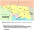
File:Banat backa baranja 02 map.png
Appearance

Size of this preview: 678 × 600 pixels. Other resolutions: 271 × 240 pixels | 543 × 480 pixels | 868 × 768 pixels | 1,224 × 1,083 pixels.
Original file (1,224 × 1,083 pixels, file size: 128 KB, MIME type: image/png)
File history
Click on a date/time to view the file as it appeared at that time.
| Date/Time | Thumbnail | Dimensions | User | Comment | |
|---|---|---|---|---|---|
| current | 20:16, 14 May 2014 |  | 1,224 × 1,083 (128 KB) | WikiEditor2004 | aesthetics |
| 20:19, 15 April 2011 |  | 1,226 × 1,083 (128 KB) | WikiEditor2004 | aesthetics | |
| 17:02, 5 July 2009 |  | 1,226 × 1,083 (128 KB) | WikiEditor2004 | ||
| 23:36, 9 February 2009 |  | 888 × 500 (26 KB) | WikiEditor2004 | historical map of Banat, Bačka and Baranja in 1918 (self made) {{PD-self}} Category:Maps of the history of Vojvodina Category:Maps of the history of Serbia |
File usage
The following 5 pages use this file:
Global file usage
The following other wikis use this file:
- Usage on el.wikipedia.org
- Usage on fr.wikipedia.org
- Usage on hr.wikipedia.org
- Usage on hu.wikipedia.org
- Usage on ja.wikipedia.org
- Usage on ko.wikipedia.org
- Usage on lt.wikipedia.org
- Usage on mk.wikipedia.org
- Usage on ro.wikipedia.org
- Usage on ru.wikipedia.org
- Usage on sh.wikipedia.org
- Usage on th.wikipedia.org
- Usage on tr.wikipedia.org
- Usage on uk.wikipedia.org
