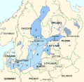
File:Baltic marine subdivisions and drainage basins.gif
Appearance
Baltic_marine_subdivisions_and_drainage_basins.gif (561 × 547 pixels, file size: 53 KB, MIME type: image/gif)
File history
Click on a date/time to view the file as it appeared at that time.
| Date/Time | Thumbnail | Dimensions | User | Comment | |
|---|---|---|---|---|---|
| current | 21:07, 27 November 2015 |  | 561 × 547 (53 KB) | Myedits2 | Changes numbering of Baltic regions and creates a drainage basin not in the source. |
| 11:06, 19 April 2014 |  | 561 × 547 (31 KB) | Ulamm | once more | |
| 11:03, 19 April 2014 |  | 561 × 547 (35 KB) | Ulamm | recoloured | |
| 00:58, 23 June 2011 |  | 561 × 547 (53 KB) | Kattegat2709 | {{Information |Description ={{en|1=2. Bothnian Sea 3. Archipelago Sea 4. Åland Sea 5. Gulf of Finland 6. Northern Baltic Proper 7. Western Gotland Basin 8. Eastern Gotland Basin 9. Gulf of Riga 10. Gdansk Basin 11. Bornholm Basin 12. Arkona Basin 13. |
File usage
The following 5 pages use this file:
Global file usage
The following other wikis use this file:
- Usage on ar.wikipedia.org
- Usage on cs.wikipedia.org
- Usage on de.wikipedia.org
- Usage on fi.wikipedia.org
- Usage on fr.wikipedia.org
- Usage on hr.wikipedia.org
- Usage on sr.wikipedia.org


