From Wikipedia, the free encyclopedia
Original file (2,953 × 4,430 pixels, file size: 9.84 MB, MIME type: image/jpeg )
Summary
Object
Photograph
I have published this image as author under the Creative-Commons-Licence CC BY-SA 4.0. . This means that free online usage outside of Wikimedia projects under the following terms of licence is possible:
The image is credited with "© Raimond Spekking / CC BY-SA 4.0 (via Wikimedia Commons)" For all other kind of usages (books, journales, flyers, etc.) click on the following button. You will get all information needed.
I would be happy to receive a specimen copy or the URL of the website where the image is used.
Please write an email to raimond.spekking@gmail.com (GPG encrypted emails are welcome: Key-ID: 0xB12BE7A6) , if you
need the image in a higher resolution
need my postal address for sending a specimen copy
have further questions to the terms of licence
Licensing
I, the copyright holder of this work, hereby publish it under the following license:
Attribution: © Raimond Spekking / CC BY-SA 4.0 (via Wikimedia Commons)
You are free:
to share – to copy, distribute and transmit the workto remix – to adapt the work
Under the following conditions:
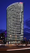
attribution – You must give appropriate credit, provide a link to the license, and indicate if changes were made. You may do so in any reasonable manner, but not in any way that suggests the licensor endorses you or your use.share alike – If you remix, transform, or build upon the material, you must distribute your contributions under the same or compatible license as the original. https://creativecommons.org/licenses/by-sa/4.0 CC BY-SA 4.0 Creative Commons Attribution-Share Alike 4.0 true true English BahnTower at Potsdamer Platz in Berlin
German BahnTower am Potsdamer Platz in Berlin
File history
Click on a date/time to view the file as it appeared at that time.
Date/Time Thumbnail Dimensions User Comment current 16:30, 21 May 2023 2,953 × 4,430 (9.84 MB) Raymond Uploaded with LrMediaWiki 1.3.0, LR 6.14 Win
File usage
The following page uses this file:
Global file usage
The following other wikis use this file:
Usage on af.wikipedia.org
Usage on ar.wikipedia.org
Usage on arz.wikipedia.org
Usage on be.wikipedia.org
Usage on bg.wikipedia.org
Usage on ca.wikipedia.org
Usage on cs.wikipedia.org
Usage on da.wikipedia.org
Usage on de.wikipedia.org
Usage on el.wikipedia.org
Usage on eo.wikipedia.org
Usage on es.wikipedia.org
Usage on eu.wikipedia.org
Usage on fi.wikipedia.org
Usage on fr.wikipedia.org
Usage on gl.wikipedia.org
Usage on he.wikipedia.org
Usage on hu.wikipedia.org
Usage on it.wikipedia.org
Usage on lb.wikipedia.org
Usage on nl.wikipedia.org
Usage on no.wikipedia.org
Usage on pl.wikipedia.org
Usage on pms.wikipedia.org
Usage on ro.wikipedia.org
Usage on ru.wikipedia.org
Usage on sk.wikipedia.org
Usage on sv.wikipedia.org
Usage on tk.wikipedia.org
Usage on tr.wikipedia.org
Usage on uk.wikipedia.org
Usage on www.wikidata.org
This file contains additional information, probably added from the digital camera or scanner used to create or digitize it.
If the file has been modified from its original state, some details may not fully reflect the modified file.


