File:BART-SJ-extension-map.png
Appearance

Size of this preview: 685 × 599 pixels. Other resolutions: 274 × 240 pixels | 549 × 480 pixels | 734 × 642 pixels.
Original file (734 × 642 pixels, file size: 203 KB, MIME type: image/png)
File history
Click on a date/time to view the file as it appeared at that time.
| Date/Time | Thumbnail | Dimensions | User | Comment | |
|---|---|---|---|---|---|
| current | 03:59, 24 March 2018 |  | 734 × 642 (203 KB) | Pi.1415926535 | correct station name |
| 00:51, 14 December 2008 |  | 734 × 642 (203 KB) | Ikluft | major cleanup - add mid-background layer with highways and highway shields | |
| 01:25, 26 November 2008 |  | 734 × 642 (243 KB) | Ikluft | additional details + minor clean-ups | |
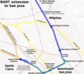
| 07:56, 22 November 2008 |  | 734 × 642 (226 KB) | Ikluft | {{Information |Description={{en|1=Map of the planned Bay Area Rapid Transit extension to San Jose. The background map of Silicon Valley was generated by the [http://nationalmap.gov/ USGS National Map]. The route and |
File usage
The following 3 pages use this file:
Global file usage
The following other wikis use this file:
- Usage on de.wikipedia.org
- Usage on nl.wikipedia.org
- Usage on zh.wikipedia.org


